Haryana State Board HBSE 9th Class Social Science Solutions Geography Chapter 4 Climate Textbook Exercise Questions and Answers.
Haryana Board 9th Class Social Science Solutions Geography Chapter 4 Climate
HBSE 9th Class Social Science Geography Climate TextBook Questions and Answers
Climate 9th Class HBSE Geography Question 1.
Choose the right answer from the four alternatives given below:
(i) Which one of the following places receives the highest rainfall in the world
(a) Silchar
(b) Mawsyi train
(c) Chefrapunji
(d) (Guahati)
Answer:
(c) Chefrapunji
(ii) The wind blowing in the northern plains in summers is known as:
(a) Kalbaisakhi
(b) Loo
(c) Mountain
(d) None of the above
Answer:
(b) Loo
(iii) Which one of the following causes rainfall during the winters in north-western part of India.
(a) Cyclonic depression
(b) Rdtrating Monsoon
(c) Western disturbances
(d) S.W. Monsoon
Answer:
(d) S.W. Monsoon
![]()
(iv) Monsoon arrives in India approximately in:
(a) early May
(b) early July
(c) early June
(d) early August
Answer:
(c) early June
(v) Which one of the following tihcrac- terises the cold weather season in India ?
(a) Warm days and warm nights
(b) Warm days and cold nights
(c) Cool days and cold nights
(d) Cold days and warm nights
Answer:
(c) Cool days and cold nights
HBSE 9th Class Geography Chapter 4 Climate Question 2.
Answer the following questions:
(i) What are the factors affecting the climate of India ?
Ans.
The factors affecting the climate of India are as under:
1. Latitude:
The Tropic ot Cancer passes through the middle of the country from the Rann of Kuchchh in the west to Mizoram in the east. Almost half of the country-lying south of the Tropic of Cancer, belongs to the tropical area. All the remaining area, north of the Tropic, is in the ‘sub-tropics. Therefore, India’s climate lias traits of tropical as well as subtropical climates.
2. Altitude:
India has mountains to the north, which have an average height of about 6,000 metres, with the highest peaks (some of them amongst the highest in the world) rising above 8,000 metres above sea level. India also has a vast coastal area where the maximum elevation is about 30 metres. The Himalayas prevent the cold winds from Central Asia from entering the subcontinent. It is because of these mountains- that the subcontinent experiences comparatively milder winters. Also temperature differences are minimised between die tropical and subtropical India.
3. Pressure and Winds:
The climate and associated weather conditions, in India, are governed by (a) pressure and surface winds, upper air circulation, western disturbances and tropical cyclones. The pressure and wind conditions over India are unique. During, winter, there is a high-pressure area north of the Himalayas, Cold dry winds blow from this region to the low-pressure areas over the oceans to the south: In summer, a low-pressure area develops over interior Asia as well as over the region surrounding the Arabian Sea, including northwestern India. This causes a complete reversal of winds during summer.
![]()
Air moves from the high-pressure area over the southern Indian Ocean, in a south-easterly direction, crosses the equator, and turns right towards the low-pressure areas over the Indian subcontinent. These are known as the South-west Monsoon winds. These winds blow over the warm oceans, gather moisture and bring widespread rainfall over India. The upper air circulation ia this region is dominated by a westerly flow. An important component of this flow is the jet stream. Jet streams, are high velocity winds blowing, through a narrow zone in the upper troposhere.
These jet streams are located approximately over 27°- 30° north latitude, therefore, they are known as subtropical westerly jet streams. Over India, the subtropical westerly jet stream blows south of the Himalayas, all through the year except in summer, The western disturbances experienced in the north and north-western parts of the country are brought in by this westerly flow. In summer, the subtropical westerly jet moves north of the Himalayas with the apparent movement of the sun. An easterly jet stream, called the tropical easterly jet blows over peninsular India, approximately at 14°. N during the summer months.
4. Relief:
The Himalayas act as a great barrier and save India from cold winds of Central Asia. On the other hand, the Western Ghats and the Khasi Hills in Meghalaya lie right across the path of the monsoon winds and cause heavy rainfall.
5. Location:
Being surrounded by the Arabian Sea, the Indian Ocean and the Bay of Bengal, India gets lots of monsoon winds. On the other hand, the desert area causes much heat. The climate of India in fact is also influenced by the climatic conditions over the rest of Asia.
(ii) Why does India have a monsoon type of climate ?
Answer:
India has a monssoon type of climate because it is strongly governed by the monsoon winds.
(iii) Which part of India does experience the highest divemal range of temperature and why?
Answer:
The Thar Desert experiences the highest diverual range of temperature due to its location.
(iv) Which winds do not account for rainfall along the Malabar coast and the Coronomdal coast?
Answer:
The south-west monsoon winds do not account for rainfall along the Malabar coast and the Coromondal coast.
(v) What are Jet streams And how do they affect the climate of India?
Answer:
The Jet streams are a narrow belt of high attitude (above 12000 m) westerly winds in the troposphere. Their speed varies from summer to winter. As it helps decrease temperature, it affects climate.
(vi) Define monsoons. What do you understand by ‘break’ monsoon?
Answer:
‘Monsoon’ word has been derived from the Arabic word ‘Mausam’ meaning season. ‘Monsoon’ is generally used to refer to indicate the rain-bearing winds which reverse their direction with the change of the season and blow” throughout the Indian sub-continent, specially‘during the summer season. By ‘breade’ of the monsoon means the sudden approach of the moisture laden winds associated with violent thunder and lighting.
![]()
(vii) Why is the monsoon considered a unifying bard ?
Answer:
The unifying influence of the monsoon on the Indian subcontinent is quite perceptible. The seasonal alteration of the wind systems and the associated weather conditions provide a rhythmic cycle of seasons. Even the uncertainties of rain arid uneven distribution are very much typical of the monsoons. The Indian landscape, its animal and plant life, its entire agricultural calendar and the life of the people, including their festivities, revolve around this phenomenon. Year after year, people of India from north to south and from east to west, eagerly await the arrival of the monsoon. It is another matter as to how much rain it brings.
Chapter 4 Climate HBSE 9th Class Geography Question 3.
Valley of Kulu is more popular with the tourists ? Why?
Answer:
The valley of Kulu is more popular with the tourists due to its favourable weather conditions.
Question 4.
Why does the rainfull decrease from east to west in the northern India ?
Answer:
The rainfall .decreases from east, to the west in the northern India because of the seasonal contrasts in the interior of the country.
Question 5.
Give reasons as to why:
(i) Seasonal reversal of wind direction takes place over the Indian subcontient.
Answer:
Seasonal reversal of wind direction takes place over,the Indian sub-continent, because in summer land gets more heated than water, it forms a low pressure over the interior landmass of Asia. Air gets to start moving from the high pressure area located over Indian ocean in the South to the low pressure areas of the North; Hence a complete reversal occurs in the wind direction.
(ii) The bulk of rainfall in. India is concentrated over a few months.
Answer:
The climate of India is known as ‘ monsoon climate. The monsoon winds arrive the June. These monsoon winds are divided into two parts and remain, upto the month of September. It is the reason that the bulk of rainfall in our country is concentrated over a few month.
(iii) The Tamil Nadu coast receives’ winter rainfall.
Answer:
Tamil Nadu coast receives rainfall in winter because of the following reasons:
In the winter season, the northern monsoon pickup moisture while crossing the Bay of Bengal. While returning in November, they cause rainfall in Tamil Nadu.
(iv) The deltas of the Godavari, the Krishna and the Kaveri are frequently struck by cyclones. .
Answer:
The Godavari, the Krishna and the Kaveri are frequently struck by cyclones because the low pressure conditions are transferred to the Bay of Bengal by early November. This shift is associated with occurrence of cyclonic depressions originating over the Andaman sea. These are very destructive cyclones which cause great damage in these areas,
![]()
(v) Parts of Rajasthan, Gujarat and the leeward side of the Western Ghats are drought prone.
Answer:
Part of Rajasthan, Gujrat and the leeward side of the Western Ghats are drought prone because these areas get very little rainfall.
Question 6.
Describe the regional variations in the climatic condition of India with the help of suitable examples.
Ans.
The climate, of India is mainly described as monsoon climate. However, it has lots of regional variations. These are the following:
1. Parts of Western Ghats and the Northern- Eastern parts of India receive more than 400 cm. of annual rainfall. On the other hand, Rajasthan, Gujarat, leeward area of Western Ghats and parts of Tamil Nadu receive only less them 40 cm. of rainfall. There are areas even getting less than 20 cm. of precipitation. While there are parts with moderate rainfall.
2. Temperature also differs from part to part. For example, in the summer season temperature in day time at Jaislmer may cross 50°C. While in a winter night temperature may fall at-45°C in Drass.
3. The parts of India like the penirtsular region does not have a well defined cold weather season. In fact in these areas there is hardly any seasonal change in the distribution pattern of temperature because of the influence of the sea. Hence it is absolutely clear that there are lots of regional variations in the climatic condition of India.
Question 7.
Discuss the mechanism of monsoons.
Ans.
The monsoons are meant by the rain¬bearing seasonal winds blowing throughout the Indian sub-continent especially during the summer season. Though the phenomenon of the monsoon is very old, yet its true nature could have been derived recently. The meteorologists have found out a seesaw in relationship between the meteorological changes going on over the Pacific and the Indian Ocean. Whenever high pressure is created in the sub-tropical region of the Pacific Ocean, it tends to be low.
This Well known fact causes the shifting of winds across the Equator in different directions. The shifting of winds across the Equator has the great bearing on. the monsoons. The monsoon winds are confined to tropical lands living between 20° N to 20°S latitudes. The Indian sub-continent, however having the Himalayan ranges, bring the whole sub-continent under the sway of the moist-bearing winds for two to five months roughly between May to October. India, infact is dependent on the monsoons of its 75%-90% rains. It is the reason of the saying, “India would have been an and land if there had been no phenomena of monsoons.”
Question 8.
Give an account of weather conditions and characteristics of cold reason.
Answer:
The cold weather season begins from mid-November in northern India and stays till February. December and January are the coldest, months. The temperature decreases from south to the north. The average temperature of Chennai, on the eastern coast, is between 24°-25° Celsius, while m the northern plains, it ranges between 10°-15° Celsius. Days are warm and nights are cold. Frost is common in the north and the higher slopes of the Himalayas experience snowfall.
During this season, the northeast trade winds prevail over the country. They blow from land to sea and hence, for most part of the country, it is a dry season. Some amount of rainfall occurs on the Tamil Nadu coast from these winds as here, they blow from sea to land. In the northern part of the country, a feeble high- pressure region develops, with light winds moving outwards from this area. Influenced by.the relief, these winds blow through the Ganga valley from the west and the northwest The weather is normally fine, marked by clear sky, low temperatures and low humidity and feeble variable winds.
![]()
A characteristic feature of the cold weather season over the northern plains is the inflow of depressions from the west and the northwest. These low-pressure systems, called the ‘Western Disturbances’, originate over the Mediterranean Sea and western Asia and move into India, along with the westerly flow. They cause the much-needed winter rains over the plains and snowfall in the mountains. Although the total amount of winter rainfall ‘mahawat’ is small, they are of immense importance for the cultivation of ‘rabi’ crops.
The peninsular region does not have a well-defined cold season. There is hardly any noticeable seasonal change in temperature pattern due to the influence of the sea.
Question 9.
Give the characteristics and effects of the monsoon rainfall in India.
Answer:
Monsoon is very,important phenomena for the climate of India. In fact, India would have been an arid land if there had been no phenomena of the monsoon. Monsoons can be divided in the following types.
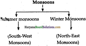
Except the east coast, of Tamil Nadu, the rest of India receives much of its rainf all in the summer by the Summer Monsoons.
The Summer Monsoons:
These are also known as the South-West Monsoons. During the summer months-March-May, the temperature rises steadily. Because of it low pressure is developed in early June, this low pressure trough is intense enough to attract even the south-east Trade winds from south of the Equator. These winds are laden; with, moistures and are defected in’lands as south-westerly winds. These winds are very strong and in about a month this time overrun almost the entire country. Nearly 90% of the rain in India comes from the monsoons which are called summer Monsoons.
The Deccan peninsula divides these monsoons into two breaches:
1. The Arabean Sea Branch,
2. The Bay of Bengal Branch.
The Arabian Sea Branch:
These monsoons strike the Western ghats and cause heavy rains in Konkar and Malabar. These monsoons become comparatively dry when they reaches the Deccan plateau and Madhya Pradesh. The other branch of the Arabian Sea Monsoons passes over west Rajasthan and the Aravalli Hills. The monsoons are quite weak here. The Aravallis lie parallel to the direction of these monsoons. Hence, Rajasthan as a whole and especially the Thar desert receives little rain.” Being very far away from the Bay of Bengal; the Thar desert does not get rain from the monsoons coming from that side. On the other hand, in the Western. Himalayas in the Himachal Pradesh hills, these winds are joined by the Bay of Bengal Winds and cause heavy rains in these areas.
![]()
The Bay of Bengal Mqnsoons:
One of the branches of the Bay of Bengal Monsoons strikes the Assam Hills, and move-towards Meghalaya and Assam. It brings very heavy rainfall over these areas. Mawsynram in Meghalaya receives the highest rainfall in the world. The other branch of these Monsoons goes Westward along the Fiimalayas, iipto the Ganga Valley. By this time it reaches the plains of Punjab. This part is comparatively dry.
The rainfall decreases as it moves westward side of the Ganga valley.
This is the reason that Kolkata receives 120 cm of rainfall while Delhi gets only 56 cms. The Winter Monsoons: These monsoons are also known as the NorthrEast Monsoons. These winds blow from the land towards the sea, so they generally bring no rain. Yet they pick up some moisture while passing over the Bay of Bengal. Hence these winds bring heavy rains along the coromondal coast. This is the reason that Tamil Nadu receives most of its annual rain in winter. That is mainly from November to March.
HBSE 9th Class Social Science Geography Climate Important Questions and Answers
Question 1.
Point out the two main characteristics of the tropical climate.
Answer:
1. Relatively high temperature almost through the year.
2. Relatively dry winters.
Question 2.
Name the monsoon winds causing heavy rains along the Tamil Nadu Cost.
Ans.
The Retreating South-West Monsoon.
Question 3.
Give two examples of equal climate.
Answer:
1. Mumbai
2. Bangalore.
Question 4.
Name two places in India with an extreme climate.
Answer:
1. Jaisalmer
2. Drass.
Question 5.
From which month the retreating south-west monsoon season in India begin ?
Answer:
October.
Question 6.
Which are the rainy months in the Tamil Nadu Coast ?
Answer:
1. October
2. November.
Question 7.
What are ‘Jet streams’?
Answer:
Jet streams’ are the fast blowing winds of a steady velocity. These winds move in a narrow zone of the upper atmosphere.
Question 8.
How many seasons can be recognised in India ? Give their names.
Answer:
In India mainly four seasons can be recognised. These are:
1. Cold weather season
2. Hot weather season
3. Monsoon season
4. Retreating monsoon season.
Question 9.
What is meant b.y the term ‘loo’?
Answer:
‘Lop’ is a type of local wind which blow in the north-western part of India. This is a very hot and dry wind.
Question 10.
Which place in . India record the highest rainfall in the world?
Ans.
Mawsyngram, located on tire crest of the southern range of khasi hills receives die highest average annual rainfall in the world.
Question 11.
Name the four months in which India receives the bulk of rainfall.
Answer:
1. June
2. July
3. August
4. September.
Question 12.
What are the ‘retreating monsoons’?
Answer:
The term ‘retreating monsoons’ indicates the reversal of the southwest monsoons which begin to withdraw from the. Northern plains by the beginning of October.
Question 13.
Which part of India experiences the highest range of temperature in a day?
Answer:
The north-western part of India particularly the desert area of Rajas than experiences the highest range of temperature in a day.
Question 14.
What are the major factors influencing the climate of India?
Ans.
The major factors influencing the climate of India are the following:
Question 15.
Name the states of the eastern coast. frequently having tropical cyclone.
Answer:
1. Andhra Pradesh
2. Tamil Nadu.
Question 16.
Name the states which are affected by ‘Kal Baisakhi’.
Answer:
1. Assam
2. West Bengal.
Question 17.
What is associated in the ‘break’ or ‘burst’ of the monsoon?
Answer:
Lightening and violent thunder.
Question 18.
What is the main ‘reason of heavy rainfall in the northeastern states ?
Answer:
The main reason of the heavy rainfall in the northeastern states are the south¬western monsoons arising from the Bay of Bengal. These directly strike the north-eastern hills of north-eastern states.
Question 19.
Why do the western slopes of the Western Ghats receive more rainfall?
Answer:
The branch of the south-western monsoon which arise from the Arabian Sea strike the western slopes of the Western Ghats and cause rainfall more than 2500 millimetres.
Question 20.
Point out the variation of the precipitation in India.
Ans.
The precipitation in India varies from over 400 cm in Meghalaya to less than 10 cm in Ladakh.
Question 21.
What is meant by the rain shadow?
Answer:
The rain shadow is meant by the axea which is the side, of the mountain not. getting enough rain. The winds after crossing the summits of the mountains descend along the slopes on the other side of the mountains. While descending they get warmed up and become dry. There is one more reason that the moist winds do not cross over the other side of die mountains which are too high as in the case of the Himalayas which also render Tibet a dry region. This dry side of the mountain is called the leeward side and the rainless area on the leeward side is known as the rain shadow.
Question 22.
Discuss the reason why do the south-west monsoons give less rain in Tamil Nadu
Or
Why Chennai is dry even when it is raining heavily on the Malabar Coast in the month of July ?
Or
Give the reasons why south-west. monsoons are less rainy in Tamil Nadu?
Answer:
Following are the reasons which ciause Chennai keeping dry even when its raining heavily on the Malabar Coast in the month of July. .
1. The Malabar Coast lies on the Western Ghats while Tamil Nadu or Chennai lies on the Eastern Ghats. In, the month of July when the monsoons arise from the Arabian sea and ‘first of all strike against the Western Ghats it rains heavily on the Malabar Codst. Hence while leaving the Western Ghats these monsoons get almost deprived of their moisture. By the time they reach the Eastern ghats after covering a long distance, they cannot provide much needed rain.
Question 23.
What is meant by the annual range of temperature ?
Answer:
The annual range of temperature is meant by the difference between the maximum and the minimum temperature of a particular place within a particular period of time.’
Question 24.
What kina ui climate is in Thiruananthpuram?
Answer:
Thiruananthpuram has an equal kind of climate; not, very cold or hot. the main reason for its equal climate is that it is situated on the sea shore. Sea always keeps this place with a moderate climate. Again this place is situated on a hill. Heiice it remains free from the hot climate of the temperate zone:
Question 25.
Why do the southwesterly winds cause rain in India?
Answer:
During the months of June-September, the South-West monsoon blow northward from the Arabian SeS and Bay of Bengal. These south-west winds cause rainfall almost in the whole of the northern India. These south-west monsoons blow from the oceanic high pressure areas towards the low pressure areas of land so they make heavy rainfall.
Question 26.
Discuss the distribution of precipitation in the country and the consequences of its uneven distribution.
Answer:
The distribution of precipitation in India is quite uneven:
1. Annual rainfall over 300, cm is received by the parts of western coast and north-eastern India. While western Rajsathan and. the adjoining parts of Gujrat, Haryana and Punjab receive rainfall even less than 50 cm.
2. The interior of the Deccan Plateau or the east of the Sahyadris, also receive low rainfall.
3. The third area of low precipitation is around Leh in Kashmir.
4. Rest of the country, receives moderate rainfall.
5. Himalayas region receives snowfall too.
Question 27.
What are the main characteristics of Arabian Sea branch of the monsoon?
Answer:
The Arabian Sea branch of Monsoon’ strikes the Western Ghats and causes heavy- rains in Konkan and Malabar. It becomes comparatively dry when it reaches the Deccan Plateau and Madhya Pradesh. The branch of the Arabian Sea Monsoon passes over West Rajasthan and the Aravalli Hills.
Question 28.
What is the reason that the rainfall decreases while going upward in the Ganga Valley but increases while going up the Indus. Valley ?
Or
How would you prove that the rainfall decreases while going eastward from West Bengal to Punjab ?
Answer:
The monsoons rise both from the Bay of Bengal as well as from the Arabian Sea. The monsoons arriving from the Bay of Bengal cause heavy rainfall in the Brahmaputra Valley. Then because of the Himalayas they take a Western turn and move up the Ganga Valley. Here as they proceed westwards, become drier and drier and cause less and less rairi moving forward. It is the reason that Kolkata receives rainfall about 120cm, Patna 100, Allahabad 15 cm and Delhi about 56′ cm. Thus, moving upward the rainfall definitely decreases. It is the reason why Punjab gets less rain than West Bengal.
Question 29.
Discuss the factors controlling die Indian weather conditions.
Answer:
The main factors controlling the Indian weather conditions are the following:
1. Atmospheric Pressure: A big part of India lies in the area of north-east trade winds which are devoid of mositure and do not give fain. This is the reason that India has a quite long arid land. But the whole country is not arid. During summer, the land of India gets heated more than its water parts. Because of this the low pressure areas, develop over the interior vast landmass of Asia and high pressure areas develop over
1. the Indian ocean in the south:
As the air moves from the high pressure area to low pressure areas, the moisture laden winds of the sea blow towards the landmass of Asia including India. These moisture laden winds cause widespread rains in India in the summer season.
2. Upper Air Circulation:
When the jet streams move eastwards, the Tibetan Highlands bifurcate them into two branches. The southern branch blow south of the Himalayas. This branch exercises an important effect on the winter weather in India.
3. Tropical Cyclones:
The jet streams are attracted towards the. tropical depression in summer weather. These depressions attract the rain bearing monsoons towards them and help in distribution of the monsoon rainfall over a large part of India.
4. The Western Disturbances:
These are brought by the jet currents. When these disturbances enter India from west and north-west during winter they cause some rain in north-western parts of India. In the summer season, these jet currents move northwards and give place to an easterly jet stream which flow Over north India along 25°N.
Question 30.
Give an account of the hot weather season in India.
Answer:
It is a well known fact that due to. apparent northward movement of the sun, the global heat belt shifts northward. Because of this fact from March to May it is hot weather season in India. In March the highest day temperatures come around 38°C. This temperature is found in the Deccan Plateau. The temperature reaches around 42°C in Gujrat and Madhya Pradesh by April. In fact temperatures around 48°C are commonly found in the north-western part of the country in May. In peninsular India, these temperatures reveal the moderating influence of the Ocean.
The summer months experience rising temperature and falling air pressure in the northern part of the country. A striking feature of the hot weather, season is the loo. The loo is meant by the strong, hot dry winds blowing during day over northern and north western India. Sometimes they even continue until late in the evening. Direct exposure to these winds may even prove to be fatal. Dust storms are very common during the month of May in northen India. These storms bring temporary relief as they lower the temperature and may bring light rain and cool breeze. This is also the season for localised thunderstorms, associated with vioent winds, terrential donwpours, often accompanied by hail. In West Bengal, these storms are known as the ‘Kaal Baisakhi:’ Towards the dose of the summer seasons, pre-monsoon showers are common especially, in Kerala and Karnataka. They help in the, early ripening of mangoes, and are often referred to as ‘mango showers’.
Objective Type Questions
Question 1.
Put (✓) before the correct sentences and (✗) before the incorrect sentences.
(i) There are variations in the form and type of predpitation.
(ii) An easterly jet stream takes its place and flows over northern India along 25°N.
(iii) The annual precipitation varies from over 400 cm in Meghalaya to less than 10 cm in Ladakh and Western Rajasthan.
(iv) Coastal areas experience more contrast in temperature condition.
(v) The climate of a place is determined by the interplay of various factors.
(vi) The pattern of air circulation is very different at the higher level of the atmosphere.
(vii) Trade winds originate from the subtropical high pressure belts of the Northern Hemisphere.
Answer:
(i) (✓)
(ii) (✓)
(iii) (✓)
(iv) (✗)
(v) (✓)
(vi) (✓)
(vii) (✓)
Question 2.
Fill up the blanks in the following sentences with suitable words :
(i) The phenomenon of the monsoon is very……………
(ii) During ………….. there is a high-pressure area in north of the Himalayas.
(iii) The Tibetan …………. act as a barrier for the westerly jet stream and it gets bifurcated.
(iv) The ………….. areas do not experience much variation in temperature.
(v) Due to apparent northward movement of the sun, the …………… heat belt shifts northward.
(vi) By early Tune, the …………. pressure conditions over the north-western plains get further intensified.
Answer:
(i) old
(ii) winter
(iii) Highland
(iv) coastal
(v) global
(vi) low.
Question 3.
Find out the correct sentences among the given ones
(i) Winds.blow from high pressure areas to the low pressure areas.
(ii) Monsoon is confined only to the tropical lands lying between 20°N and 20°S.
(iii) During winter, there is a high pressure area south of the Himalayas.
(iv) Port Darwir is in the Northern Territory of Australia.
(v) The meteorological department of India makes a long term prediction of the monsoons linkely behaviour on the absis of 16 parameters.
Answer:
Correct Sentences – (ii)(iv),(v).
Question 4.
Match the List I with the List II: List II
| List I | List II |
| (i) Kolkota | 120 |
| (ii) Patna | 56 |
| (in) Allahabad | 102 |
| (iv) Delhi | 91 |
Answer:
| List I | List II |
| (i) Kolkota | 120 |
| (ii) Patna | 102 |
| (in) Allahabad | 91 |
| (iv) Delhi | 56 |
Question 5.
Choose the right answer from the four alternatives given below:
(i) The following is an example of extreme climate:
(a) Mumbai
(b) Chehnai
(c) Kolkata
(d) Jaisalmer.
Answer:
(b) Chehnai
(ii) The following is an example of the equable climate:
(a) Delhi
(b) Banglore
(c) Jaipur
(d) Lucknow
Answer:
(d) Lucknow
(iii) Where do the cyclones depression originate?
(a) In Rajasthan
(b) In Arabian Sea.
(c) In Andaman Sea
(d) In Madhya Pradesh
Answer:
(c) In Andaman Sea
(iv) Where do the Arabian Sea and the Bay of Bengal branch of the monsoon merge in the Ganga plains?
(a) north western part
(b) north eastern part
(c) south-western part
(d) south-eastern part
Answer:
(a) north western part
(v) “El Nind” is a word from the following language:
(a) English
(b) French
(c) Spanish
(d) German
Answer:
(c) Spanish