Haryana State Board HBSE 9th Class Social Science Solutions Geography Chapter 2 Physical Features of India Textbook Exercise Questions and Answers.
Haryana Board 9th Class Social Science Solutions Geography Chapter 2 Physical Features of India
HBSE 9th Class Social Science Geography Physical Features of India TextBook Questions and Answers
Geography Chapter 2 Physical Features Of India Notes HBSE Question 1.
Choose the right answer from the four alterhatives given below:
(i) A landmark bounded by sea on three sides is regerred to as
(a) Coast
(b) Island
(c) Peninsula
(d) name of the above
Answer:
(b) Island
(ii) Mountain ranges in the eastern part of India forming its boundary with Myanmar are collectively called as
(a) Himachal
(b) Uttranchal
(c) Puryanchal
(d) name of the above
Answer:
(c) Puryanchal
(iii) The western coastal strip, south of Goa is referred to as
(a) Coromandal
(b) Konkan
(c) Kannad
(d) Northern Circus
Answer:
(b) Konkan
![]()
(iv) The highest peak in the Eastern Ghats is
(a) Anai Mudi
(b) Kanchenjunga
(c) Mahendragiri
(d) Khasi.
Answer:
(d) Khasi.
Physical Features Of Haryana HBSE 9th Class Question 2.
Answer the following questions briefly:
(i) What are tectonic plates?
Answer:
Tectonics plates are those plates which form the crust of the earth. They are seven major “and some minor plates.
(ii) Which continents of today were part of the Gondwana land?
Answer:
Parts of Asia/Australia, Africa and South America.,
(iii) What is the bhabar?
Answer:
The narrow belt comprising of the pebbled beds parallel to slope of the river is callted bhabar.
(iv) Name the three major divisions of the Himalaya from north to south.
Answer:
1. The inner Himalayas (Himadri)-average altitude-6000m (aprox)
2. The middle Himalayas (Himachal)-average altitude-5000 m (aprox)
3. The outer Himalayas (Shivalik)- average altitude-1000m (aprox).
(v) Which plateau lies between theAravali and the Vaidhya ranges.
Answer:
The plateau which lies between the Aravali and the Vindhayan ranges is known the Central Highlands.
(vi) Name the island group of India having coral origin.
Answer:
Lakshdweep island groups.
![]()
Chapter 2 Physical Features Of India HBSE 9th Class Question 3.
Distinguish between:
(i) Converging and diverging tectonic plates.
Answer:
(a) Those plates which come towards each other are converging tectonic plates, those which move away from each other are called the diverging tectonics plates.
(b) Converging tectonics plates may either collide or crumble; diverging tectonics plates do not collide.
(c) Converging technics plates move harizontally past each other while the diverging plates do not do so.
(d) The movement of convering tectonics plates have, over the million years, changed the position of the continents; while the diverging tectonics plates do not have such features,
(ii) Bhangar and Khadar.
Answer:
Bhangar:
1. It belongs to the category of old alluvium soil.
2. It contains Kakar nodules with calcium carbonates.
3. It is comparatively less fertile.
Khadar:
1. It is the new Category of alluvium soil.
2. It is pure soil.
3. It is more fertile.
(ii) Western Ghats and Eastern Ghats
Answer:
Western Ghats Eastern Ghats:
1. These areSituated on the west coast of India.
1. These are situated on the east coast of India.
2. These consists Sahyadri, Nilgiri, Annamali and. the Cardamom.
2. These consist of discontinuously low hills.
3, The height of the Western Ghats goes on increasing towards the south.
![]()
Physical Features Of India Solutions HBSE 9th Class Question 4.
Describe how the Himalayas are formed.
Answer:
The Himalayas are not very old mountains. Their origin is, in fact, comparatively more recent. Before the Himalayas originated, there was the sea Tethys which slowly got filled by the silt brought by different rivers. When their mountains were formed due to the internal activities of the earth, the different layers and folds, maintained their identity.
Question 5.
Which are the major physiographic divisions of India? Contrast the relief of the Himalayas region with that of the Peninsular plateau.
Answer:
The major physiographic features of India are:
- The Himalayan Mountains
- The Northern Plains
- The Peninsular Plateau
- The coastal Plains
- The Islands
The relief features of the Himalayan region and the Peninsular Plateau can be contrasted in relation to their characteristics. The land of India displays great physical contrasts. Geologically, the Peninsular Plateau constitutes one of the ancient landmasses on the earth’s surface. It is also the most stable land block. The Himalayas and the other mountains of the North and the Plains lying between them and the Deccan Plateau display the most recent developments.
Tectonically, they form of unstable zones. Over the millions of years, the denudational processes have made these contrasts even sharper. In sharp contrast to the very .youthful, topography with sheer, lofty peaks, and steep-sided valleys of the mountains, composed of sedimentary and metamorphic rocks, the Northern Plains composed of alluvium, represent one of the world’s largest deposition surfaces. In the south the Peninsular plateau composed of igneous and metamorphic rocks depict a senile topography dominated by gently rising ridges and wide valleys. Howsoever, diverse, there exists a complementarity between these land features.
![]()
Question 6.
Give an account of the Northern Plains of India
Answer:
The Northern plains of India have a rich soil cover, favourable climate and adequate water supply to support agriculture. These are an area with almost a level plain with little variation in relief. In this area agriculture gets support from the favourable climate artd adequate water supply. The Himalayan rivers while flowing down the slopes of the mountain form alluvial fans reaching the plains. The Northern plain of India extends between the mouths of the Indus and the Ganga-Brahmaputra.
It covers a distance of nearly about 3200 km: its width varies between 300-150 km. This area gets however towards the east. At Hard war the Ganga enters the Northern Plains. On its way to the sea, it is joined by a number of. tributaries both from the north and south. The Ganga atter reaching West Bengal, turns south. The Sunderban delta of Northern India is formed by the Ganga and die the Brahmaputra. On the basis of the difference in the relief, the Northern plain is divided mainly into four parts: 1 Bhabar, 2. Tarai, 3. Bhangar, 4. Khadar.
Question 7.
Write short notes on the following:
(i) The Indian Desert
(ii) The Central Highlands
(iii) The Island groups of India
Answer:
(i) The Indian Desert lies towards the western margins of the Aravali Hills. It is a sandy plain covered with sand dimes. This region receives very low rainfall below 150 mm per year. It has arid climate with low vegetation cover.
(ii) The Central Highlands.
Answer:
The Central Highlands are the important parts of the Peninsular Plateau. The Central Highlands are mainly made of hard igneous rocks. This part is occupied by the Aravalli range. The Central Highlands,, running in a southwest-northeast direction from Gujrat to Delhi. The Thar Desert lies to the west of this part. The southern boundary of the Central Highlands is demarcated by the Vindhya range. The eastern boundary of this area extends to the Kashmir hills. The middle section of the Central Highlands falls between the valley of Narmada and the Son.
![]()
(iii) The Island groups of India.
Answer:
The Island groups of India are of different origin. In India, there are two Island groups:
1. The Lakshadweep.
2. The Andaman and Nicobar.
The Lakshadweep consists of many small islands Which, lie opposite the coast of Kerala in the Arabian Sea. The southernmost island of this group is very close to the Maldives. The islands of this group are formed of coral deposits. On the other hand, the Andaman and Nicobar islands are bigger is size. They are more numerous and scattered. Andaman has about 200 islands while the Nicobar group contains 19 islands. These islands are spread over 350 km. However, only a few of them spread over 350 km. These island groups are of great strategic importance for the country.
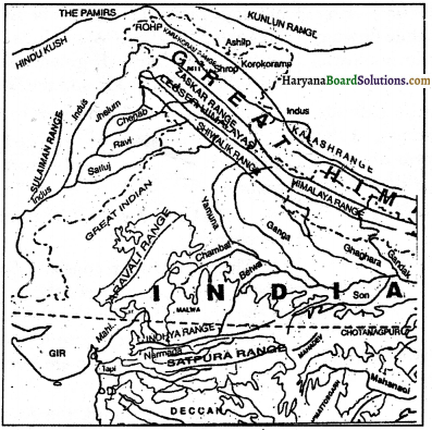
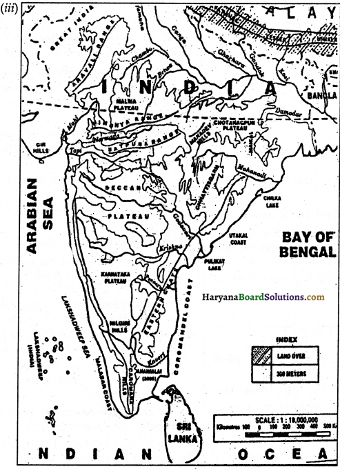
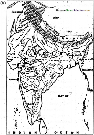
Map Skills:
On the outline map of India, show the following
(i) Mountain and hill ranges: the Karakoram, the Zaskar the Patkai Bum, the Jaintia, the Vindhya range, the Aravali and the Cardamom hills.
(ii) Peaks: K2, Kunchanjunga, Nanga Porbat, and the Anai MudL
(iii) Plateaus: Chhotanagar and Malwa
(iv) The Indian Desert, Western Ghats, Lakshadweep Islands.
Answer:
HBSE 9th Class Social Science Geography Physical Features of India Important Questions and Answers
Question 1.
What is the name of the highest range of the Himalayas?
Answer:
Himadri.
Question 2.
What is the average altitude of the Himalayas?
Answer:
4000 metres.
Question 3.
What is the length of the Himalayas?
Answer:
Nearly 2500 km.
Question 4.
Point out the height of the highest peak of the world.
Answer:
The highest peak of the world is Mount Everest. Its height is 8848 mts.
![]()
Question 5.
What is meant by an I-shaped valley?
Answer:
An I-shaped valley is meant by a valley having vertical walls on either sides.
Question 6.
Name the state where Sahyadri is located.
Answer:
Maharashtra.
Question 7.
What do you know about Ghilka?
Answer:
Chilka is one of the freshwater lagoons of the eastern coastal plain of India.
Question 8.
By which name Dihang is famous?
Answer:
The Brahmaputra.
Question 9.
What is a bar?
Answer:
It is a deposit of sand or mud in a river channel.
Question 10.
Which hills are comprised by the. Purvachal?
Answer:
The Patkai Bum, The Naga hills, The Mizo hills.
Question 11.
How the alluvial fans are formed?
Answer:
The alluvial fans are formed by the Himalayan rivers which flow down the slopes of the mountains and reach the plains.
![]()
Question 12.
What is the famous name of Tsangpo?
Answer:
The Brahmaputra.
Question 13.
Point out the characteristics of I-shaped valleys.
Answer:
I-shaped valleys have steep vertical’ walls on either side of the river.
Question 14.
In how many directions the Himalayas are divided into east-west directions?
Answer:
Four.
Question 15.
What is the height of Nanda Devi?
Answer:
7817 mtrs.
Question 16.
Where is the Satpura range located?
Answer:
In 1. Madhya Pradesh and in 2. G.ujrat.
Question 17.
Where is Sh’iwalik?
Answer:
In 1. Himachal Pradesh and in 2. Uttaranchal.
Question 18.
In which coast is cochin situated?
Answer:
Malabar.
Question 19.
Where is New Moor Island?
Answer:
In the Bay of Bengal.
Question 20.
To which physiographic division of India does the Aravalli belong?
Answer:
To the Mountainous Range.
![]()
Question 21.
Which two forces are responsible for shaping the present landform features of India?
Answer:
The two forces, mainly responsible for shaping the present landform features of India are the following:
1. Internal movements below the earth’s crust.
2. External forces operating on the surface of the earth.
Question 22.
What are tectonic plates?
Answer:
Tectonic plates are also known as the lithospheric plates*. These are the plates which are resulted from the internal heat of the earth and the currents of the semi-molten rocks which begin to move towards the crust and tear it apart dividing into large plates. These are the seven major tectonic plates:
1. South America.
2. North America,
3. Eurasian
4. Antarctica
5. Pacific
6. Indo- Australian
7. Africa.
Question 23.
Which continents of today were part of the Gondwanaland?
Answer:
The continents of today which were part of Ganwanaland are the following:
1. South America
2. Africa
3. Australia,
4. Antarctica
5. Parts of Asia including India.
Question 24.
What is the ‘Bhaba.r’?
Answer:
Bhabar is one of the most important types of Indian relief. In fact, a narrow belt covered with pebbles lies along the foot of the Shiyaliks from the Indus to the Tista. These are laid down by numerous streams descending the slope of the river bed. This belt is about 80 to 16 km in width and is known as the ‘Bhabar’.
Question 25.
Why is the peninsular massif considered the oldest landmass?
Answer:
The peninsular massif is considered the oldest landmass because, it is, geologically, one of the ancient landmasses on the earth’s surface. It was once a part of the Gondwanaland till its surface and drifting, laying somewhere near the south pole along with Australia, South Africa and South America.
![]()
Question 26.
How are the Himadri Himalayas different from the Himachal Himalayas?
Answer:
The difference between the Himadri Himalayas and the Himachal Himalayas can’ be stated as under: Himachal Himalayas
1. This range of the Himalayas is the middle range of the Himalayas.
2. It is also known as the middle Himalayas.
3. Its average altitude is between 3700 and 4500 metres.
4. It contains all the important hill stations, for example: Dharamsala, Dalhousie, and Shimla.
Question 27.
Distinguish between Island group of the Bay of Bengal and the Arabian See.
Answer:
Island and Groups of the y of Bengal:
1. The Andaman and Nicobar group of islands .lay in the Bay of Bengal.
2. This group of islands consists of as many as 200 islands spread Over an area of 350 km.
3. The islands are large and numerous.
4. The islands form a lush green, densely forested and pictures of the archipelago.
Island Groups of the ArabianSea:
1. The. Lakshadweep group of islands lay in the Arabian Sea.
2. This group- of islands consists of small coral islands. These are 36 in number spread over to a mere 32 sq kms.
3. These islands are small and less numerous.
4. The islands are characterised by a’great diversity in terms of flora and fauna.
Question 28.
Give reasons:
(i) Siwaliks are prone to landslides.
(ii) Eastern coastal plains are more fertile.
Answer:
(i) As the Siwaliks are made of unconsolidated sediments, they are prone to landslides. .
(ii) As the eastern coastal plains have thick- alluvial deposits in the delta tracks, they are relatively more fertile.
Question 29.
Explain the characteristic features of the Peninsular Plateau.
Answer:
The following are the characteristic features of the Peninsular plateau:
- It is a table land composed of the old crystalline ignores and metamorphic rocks.
- It is the oldest landmass, formed due to the .breaking and drafting of the Gondwanaland.
- It represents a senile topography charactersied by broad and shallow valleys and rounded hills.
- divided into two broad divisions
Question 30.
How are the Arbian sea formed?
Answer:
During the formation: of the Himalayas, an extensive volcanic eruption took place iij the north-western part of the plateau. This part was subsided, the Indian Ocean advanced to occupy- this depression And it resulted into the formation of the Arabiansea.
![]()
Question 31.
Write short notes on the following;
(i) The Middle Himalayas.
Answer:
The MiddleHimalaya is,also Rnwon as Himachal. It lies to the southof the Himadri,
It extends oyer an average width of 50 km and have an altitude of 3700-4500 mtrs. The main ranges of the MiddleHimalaya are:
1. The Pir Panjal
2. The Dhaoladhar
3. The Mahabharat.
The Middle Himalaya is the part of Himalaya which contains all the important hills stations like:
1. Dharmashala
2. Dolhousie
3. Shimla
4. Mussorie
5. Darjeeling etc.
Question 32.
Distinguish between
(i) A Delta and Estuary.
(ii) A Tributary and A Distributary
Answer:
(i) A Delta and Estuary
1. It is generally a triangular land form, formed by the deposition of segments at the inouth of river.
2. It is always formed by a river.
3. A delta resembles the Greek letter A.
A Delta An Estuary
1. It is a narrow deep valley at the mouth of a river
2. It is formed where the currents and tides are strong.
3. This is formed when the sediments are automatically removed before they are depositied. Hence the mouth of the river remains clear.
(ii) A tributary and a distributary:
A Tributary:
1. It is a river or a stream joining a larger river.
2. It joins the main river by adding waters from its basin.
3. Yamuna is an example of a tributary of Ganga.
4. It is responsible for the increase in the volume of water of the main river.
A Distributary:
1. It is the channel which is formed by a river at its mouth.
2. It carries away a part of the water from the main river.
3. Ganga while entering the .Bay of Bengal forms’ many distributaries.
4. It decreases the volume of water of the main river.
![]()
Question 33.
Describe how the Himalayas were formed.
Answer:
Formation of the Himalayas: The Indo-Australian plate which was separated from the Gondwanaland cfrifted slowly towards north. It collided with the much.larger Eurasian plate in the northern hemisphere approximately 5 crores of years ago. The northern edge of the Indo-Australian plate was.pushed beneath the Eurasian plate. Under the impact of this collision, the sedimentary rocks of the enclosed ocean were folded to form the mountain system of central Asia including the Himalayas.
Question 34.
Differentiate between the plateau and the plain.
Answer:
Plateau is an elevated land which has a relatively extensive and levelled surface. A plateau is generally bound by deep slopes on one or more sides. The plateau rises abruptly. Plateau is comparatively cooller than the plains. A plateau is uneven and rocky.
Plain:
It is an area which is flat and Ibw-lying. This area generally does not go above 300 metres from the sea level.
Question 35.
Point out some of the main features of the Ganga-B rahmap utra Delta.
Answer:
1. Ganga-Brahmaputra Delta is the largest delta in the world.
2. It is obviously a well-watered delta.
3. It is the most fertile delta of the world.
4. The lower part of this delta has become marshy owing to the free mingling of river and sea waters by the high and low tides.
Question 36.
Write down the main features, of the Ganga Basin.
Answer:
1. The Ganga Basin is the largest part, of tire Great Northern Plain.
2. The Ganga Basin lies to the south of the Himalayas.
3. The Ganga Basin extends from Ambala to Sunder ban.
4. It is nearly 1800 Km. long.
5. A large number of perennial rivers flow through this plain.
6. These rivers are very useful in irrigation.
7. It provides a large scope for generating hydel power.
Question 37.
Do you agree that the physiographic divisions of India are complementary. to each other?
Answer:
India is a vast country with lots of variety. These varieties are also seen in the physiographical divisions of India. These diversities and divisions are, however, complementary to each other.
For example, all the three major divisions:
1. The Great Mountain’ Wall of the North
2. The Northern Plains
3. The Great Peninsular Plateau, are complementary to each other.
The Northern Mountains are the major source pf water. On the other hand, the Peninsula has provided the stable block which went a long way in building the Northern plains and the Mountains. The Northern plains which provide fertile sites, get fertility from the Himalayan rivers. The- peninsular plateau is also of equal importance. The western ghats of this part play important role in monsoon rain.
![]()
Question 38.
The Himalayas are of great importance to India, Discuss.
Answer:
The Himalayas are no doubt of great importance for India in physical as well as in historical aspects. Physiographical Importance: The Himalayas are the lofty and impassable natural barriers on the northern border of India. The Himalayas act like a natural wall keeping the fertile Indo-Gangetic plains Safe from the cold bleak winds from the North. The Himalayas provide us the water sources like the Ganga flowing throughout the year.
The Himalayas also check the rain-bearing monsoon winds from the Indian Ocean which would otherwise blow across the north. The Himalayas cause the monsoon winds to shower on the valleys and the plains to their south. By this the Himalayas make the Indo-Gangetic plain the most fertile and productive plain in the world.
Natural Beauty:
The Himalayan peaks are snow-coveted throughout the year. As such they provide attractive natural spots inviting tourists from all over the world.
Historical Importance:
In ancient times the Hitnalayas also, stood as a firm security guard providing safety to the Indian parts from the invading hoards from the North.
Question 39.
Which are the major physiographic divisions of India?
Answer:
The major physiographic: divisions 6f Indiaarethe following
1. The Great Himalayan Mountains: These folded mountains extend from Kashmir to Arunachal Pradesh in northern India. The and thfe,, width varies from 230-400 km. The Himalayas are further divided into three
(a) is the northernmost range of the Himalayas. This range is also known as Great Himalaya or Inner Himalaya. The. average altitude of this range in about 6000 metres. This range contains all the prominent peaks including Mount Everest, the highest peak in the world.
(b) Himachal: It is the middle Himalaya extended over an average width of 50 km and have an altitude of 3700 to 4500 metres. Pir Panjal, Dholadhar, and Mahabharat ranges are the parts of this group. All the important hill stations of North India like Dharmashala, Dalhousie, Shimla, and Darjeeling are located on this range.
(c) Shivalik: This is also known as Outer Himalaya. These ranges extend over the width of 10-50 km and have an altitude between 900 and 1100 metres.
2. The Northern Plains: It is almost a level plain with little variation in relief. The river valley civilizations of the Indus and the Ganga flourished in the region as they were based on the cultivation of crops. This part of the country is almost a level plain with little variation in relief. This part of the plain area extends between the mouths of the Indus and the Ganga-Brahmaputra covering a distance of about 3200 km.
3. The Peninsular Plateau: This is the oldest part of the Country. This is a triangular region with its base towards the Northern plains, between the Delhi ridge and Kajmahal Hills. This part has a general deviation of about 600-900 metres.
![]()
This part is again sub-divided into two parts:
1. The Central Highlands
2. The Deccan Plateau.
4. The Coastal Plains: This part is divided into the eastern and the western coastal plains. The western coastal plain stretches from Gujrat to Kerala.
5. The Islands: The Indian island groups are of different origins. The island of Lakshadweep group are formed of coral deposits. The Andaman Nicobar islands are bigger in size. They are more numerous and scattered.
Question 40.
Point out the general characteristics of the great Northern Plain:
Or
Describe the main features of the Northern Plain.
Answer:
1. The great Northern Plain extends from the Punjab Plain in the west to the Brahmaputra Valley in the east.
2. This plain lies to the south of the Himalayas.
3. This plain possesses the alluvial deposites of the Ganga, Indus and the Satluj.
4. The rivers flowing in this region are perennial.
5. The average of this plain is less than 300 metres above sea-level.
6. The largest part or this area is formed by the Ganga
7. This region has rich alluvial soil and abundant Water supply. The means of livelihood are easily available here.
8. The density of the population is the highest in this region.
9. The other part of the great Northern plain is formed by the Punjab plain.
10. The eastern part of the great-northern plain.
11. In the southeastern side of the Northern plain lies the Ganga Brahmaputra Delta. It is the largest delta in the world.
Question 41.
Write a detailed note on the Western Ghats and the Eastern Ghats.
Answer:
The Western Ghats and the Eastern Ghats mark the western and the eastern edges of the Deccan Plateau respectively. Running
parallel to the western coast, the Western Ghats display great structural unity. They are continuous and can be crossed through passes only such as locations of Thai, Bhor and the Pal Ghats. These passes provide passages to the rail and the roads. The Western Ghats are higher than the Eastern Ghats. Their average elevation is 900-1600 metres as against 600 metres of the Eastern Ghats. The Eastern Ghats stretch from the Mahahadi Valley to the Nilgiris in the south.
The Eastern Ghats are discontinuous and irregular and dissected by rivers draining into the Bay of Bengal. The Western Ghats cause orographic rain by blocking the rain-bearing moist winds along the western; slopes of the Ghats. The Western Ghats are known by different local names. The height of the Western Ghats progressively increases from north to south.
![]()
The highest peaks include the Anai Mudi (2,695 metres) and the Doda Betta peak (2,633 metres). Mahendragiri (1,500 metres) is the highest peak in the Eastern Ghats. Shevroy Hills and the Javadi Hills are located to the south east of the Eastern Ghats. All the rivers draining the eastern coastal plains have their sources in the Western Ghats.
Question 42.
Write a note on the Shiwaliks.
Answer:
The outermost range of the Himalayas is called the Siwaliks. They extend over a width of 10-50 Km and have an altitude varying between 900 and 1100 metres. These ranges are composed of unconsolidated sediments brought down by rivers from the , main’ Himalayan ranges located farther north.
The Siwaliks form almost a continuous chain to the south of the Himachal from Jammu and Kashmir to Arunachal Pradesh. Flat-bottomed strike valleys separate large portions of Siwaliks, at places. These valleys, covered with thick gravel and alluvium, are called, ‘duns’. The Dehra Dun, Kotli and Patli Duns are some of the dims.
Objective Type Questions
Question 1.
Put (✓) before the correct sentences and (✗) before incorrect sentences.
(i) The Peninsular block may be subdivided into two parts.
(ii) Next to bhabar there is bhangar.
(iii) The Deccan plateau is situated between Delhi Ridge and Rajmahal Hills.
(iv) The Deccan plateau extends southward from the Satpura.
(v) The southern part of the Western Ghats is relatively smaller.
(vi) Atolls in Malayalam refer to die ring.
(vii) There are about 120 islands in the Andaman group.
(viii) Lagoons are saltwater lakes.
Answer:
(i) ✓
(ii) ✗
(iii) ✗
(iv) ✓
(v) ✗
(vi) ✓
(vii) ✗
(viii) ✓
Question 2.
Fill up the following blanks:
(i) Atolls are …………… or horseshoe-shaped coral reefs.
(ii) Rivers of the western coast from …………..
(iii) Nicobar group has ………….. islands.
(iv) The …………. coastal plain is comparatively much wider.
(v) The coast of southern Andhra Pradesh and Tamil Nadu is popularly known as ………….
Answer:
(i) circular
(ii) estuaries
(iii) 19
(iv) eastern
(v) Coromandal coast.
![]()
Question 3.
Match out the following two lists.
| List I | List II |
| (i) Parasanth | Mountain |
| (ii) Mannar | River |
| (iii) Vembanad | Gulf |
| (iv) Minicoy | Plateau |
| (v) Malwa | Hills |
| (vi) Bhima | Lake |
| (vii) Kardamun | Island |
| (viii) Khyber | Pass |
Answer:
| List I | List II |
| (i) Parasanth | Hills |
| (ii) Mannar | Gulf |
| (iii) Vembanad | Lake |
| (iv) Minicoy | Island |
| (v) Malwa | Plateau |
| (vi) Bhima | River |
| (vii) Kardamun | Mountain |
| (viii) Khyber | Pass |
Question 4.
Answer The following questions in yes or no
(i) The Mahanadi river flows through Gujrat.
(ii) The cost is one of the tributaries of the Ganga.
(iii) The Tropic of cancer passes through the Rann of Kachina.
(iv) 10° Channel passes through Madhya Pradesh.
(v) Satpura is a famous river.
(vi) The son river is touched by the Equator.
(vii) Andaman sea is on the western side of India.
(viii) Khasi Hills are on the eastern side of India.
Answer:
(i) No
(ii) Yes
(iii) Yes
(iv) No
(v) No
(vi) No
(vii) No
(viii) Yes.
Question 5.
Choose the right answer from the four alternatives given below:
(i) The Go.ndwanaland was in the following part of Are ancient supercontinent:
(a) southern
(b) eastern
(c) western
(d) northern
Answer:
(a) southern
(ii) The following sea was situated between the Angaraland and the Gondwanaland in the geological part:
(a) the Arabian Sea
(b) the Bay of Bengal
(c) Tethys
(d) the Black Sea.
Answer:
(c) Tethys
(iii) The following is not a part of the Purvanchal:
(a) Patkai Bum
(b) Naga Hills
(c) Pir Panjal
(d) Mizo Hills.
Answer:
(c) Pir Panjal
(iv) The following is a part of the Western Ghats:
(a)Anai Rudi
(b) Shevroy
(c) Javadi
(d) None of these.
Answer:
(c) Doda Betta
(iv) The following is a part of the Eastern Ghats:
(a) Javadi
(b) Anai Mudi
(c) Doda Betta
(d) None of these;
Answer:
(a) Javadi