Haryana State Board HBSE 9th Class Social Science Solutions Geography Chapter 1 India-Size and Location Textbook Exercise Questions and Answers.
Haryana Board 9th Class Social Science Solutions Geography Chapter 1 India-Size and Location
HBSE 9th Class Social Science Geography India-Size and Location TextBook Questions and Answers
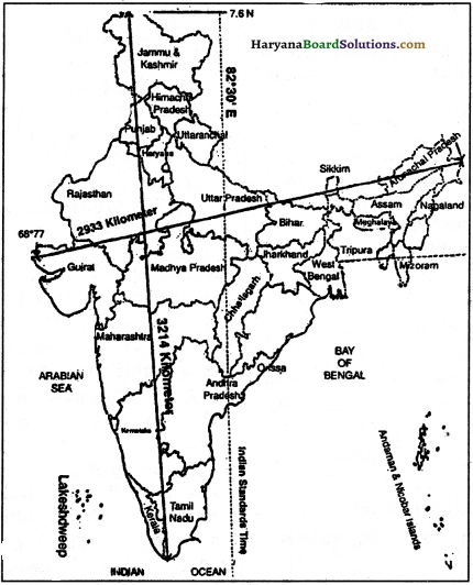
Standard Meridian HBSE 9th Class Question 1.
Choose the right answer from the four alternatives given below:
(i) The Tropic of Cancer does not pass through:
(a) Rajasthan
(b) Orissa
(c) Chhattisgarh
(d) Tripura
Answer:
(b) Orissa
(ii) The easternmost longitude of India is:
(a) 97° 25′ E
(b) 68°7’E
(c) 37° & E
(d) 82° 32’E.
Answer:
(a) 97° 25′ E
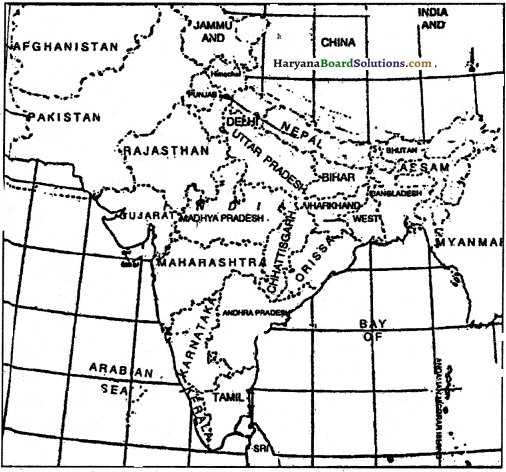
(iii) Uttaranchal, Uttar Pradesh, Bihar, West Bengal and Sikkim have common frontiers with:
(a) China
(b) Bhutan
(c) Nepal
(d) Myanmar.
Answer:
(c) Nepal
![]()
(iv) If you intend to visit the island Kavaratti during your summer vacations, which one of the following Union Territory of India you will be going to:
(a) Pondicherry
(b) Lakshadweep
(c) Andaman and Nicobar
(d) Diu and Daman.
Answer:
(c) Andaman and Nicobar
(v) My friend hails from a country which does not share land boundaries with India. Identify the country
(a) Bhutan
(b) Tajikistan
(c) Myanmar
(d) Nepal
Answer:
(c) Myanmar
India Size And Location HBSE 9th Class Question 2.
Answer the following question briefly.
(i) Name the group of islands lying in the Arabian sea?
(ii) Name the countries which are larger than India?
(iii) Which island group of India lies to its south-east
(iv) Which island countries are our southern neighbours?
Answer:
(i) Lakshadweep
(ii) Russia, China, Canada, USA, Brazil, and Australia.
(iii) Andaman-Nicobar Islands
(iv) Sri Lanka, Maldives.
Size And Location Of India HBSE 9th Class Question 3.
The sun rises two hours earlier in Arunachal Pradesh as compared to Gujarat- in the West, but the watches show at the same time. How does this happen?
Answer:
The two hours difference between Gujarat and Arunachal Pradesh is because of the two hours time lag. Though the sun rises two hours earlier in Arunachal Pradesh than in Gujarat as also in Jaisalmer, yet the standard time remains the same in the whole of the country.
![]()
Class 9 Geography Chapter 1 Map Skills Answer HBSE Question 4.
The central location of India at the head of the Indian Ocean is considered to be of great significance. Why?
Answer:
India’s location at the head of the Indian Ocean is itself of great significance. This is evident from the following:
1. Because of this location India was able to establish close cultural and commercial contacts with other .countries.
2. Due to this location, countries of East Africa, West Asia, East Asia, and South and South-West Asia could be reached easily through sea routes.
3. India’s eminent position in the Indian Ocean realm justifies naming an ocean after it.
4. Because of this location, India is able to maintain direct trade relations not only with the neighbouring countries but also with all the countries of the world.
5. Due to this position India gets a very vast and open market very near to it.
Map Skills
India Size And Location Class 9 Questions Answers HBSE Question 1.
Identify the following with the help of map reading:
Answer:
(i) The Island groups of India lie in the Arabian Sea and the Bay of Bengal.
(ii) The countries constituting the Indian Subcontinent.
(iii) The States through which the Tropic of Cancer passes.
(iv) The northernmost latitude in degrees.
(v) The southernmost latitude of the Indian mainland in degrees.
(vi) The eastern and the western most latitude in degrees.
(viii) The place situated on the three seas.
(ix) The strait separating Sri Lanka from India.
(x) The Union Territories of India.
Answer:
See the following two maps (i) and (if) of India below:
Map (ii)
Answer:
Hints:
(i) Lakshadweep islands in the Arabian sea and the Andaman and Nicobar Islands in the Bay of Bengal.
(ii) Pakistan, Nepal, Bangladesh, Bhutan, Sri Lanka, Maldives, Myanmar.
(iii) Gujarat, Rajasthan, Madhya Pradesh, Chhatisgarh, Jharkhand, West Bengal, Tripura, Mizoram.
(iv) Indian union (Indira Point) and tne Mariland (Kanyakumari).
(v) 37%’N.
(vi) 8°4′ N.
(vii) 68° 7 E and 97° 25’E,
(viii) Nepal, Bhutan.
(ix) Kanyakumari.
(x) The Palk Strait.
(xi) Delhi, Chandigarh, Pondicherry,
Lakshadweep, Daman and Diu, Dadra and Nagar Haveli, Andaman and Nicobar Islands.
![]()
HBSE 9th Class Socia Science Geography India-Size and Location Important Questions and Answers
India Size And Location Class 9 Important Questions HBSE Question 1.
Name the island group of India lying in the Bay of Bengal.
Answer:
The Andaman and Nicobar Islands.
Geography 9th Class Chapter 1 HBSE Question 2.
Which island group of India lies to its southwest?
Answer:
Lakshadweep.
Question 3.
Which canal shortened the distance between India and Europe?
Answer:
Suez canal.
Question 4.
Which ocean will have to be crossed by a ship going from Singapore to Mogadishu.
Answer:
Indian ocean.
Question 5.
Point out the latitudinal extent of India.
Answer:
The latitudinal extent of India extends between 8° 4′ N and 37° 6′ latitudes touching Jammu and Kashmir in the North and Tamil Nadu in the south.
![]()
Question 6.
Name the southernmost point of the Indian Union.
Answer:
The Indira Point. 0 °
Question 7.
Where does the Indira point lie?
Answer:
In Andaman and Nicobar.
Question 8.
When was the Suez Canal opened?
Answer:
In 1869.
Question 9.
What is the importance of the Suez Canal for India?
Answer:
Suez Canal has reduced the distance between India and Europe by 7000 km.
Question 10.
Where is Cape of Good Hope?
Answer:
In South Africa.
Question 11.
Write the two routes by which India can reach North America, South America and Europe.
Answer:
These routes are –
(i) The Cape of Good Hope
(ii) The Suez Canal.
Question 12.
Name the countries which are- larger than India in area.
Answer:
- Russia
- Canada
- China
- the United States, of America
- Brazil
- Australia.
Question 13.
Which topic divides India into two arts?
Answer:
Tropic of Cancer
Question 14.
What is the shape of the areas to the south of the Tropic of Cancer?
Answer:
Triangular.
![]()
Question 15.
What is the extension of the mainland of India?
Answer:
The mainland of India extends between 8° 4′ N and 37° 6′ N latitudes and 68° 7′ E and 97° 25’E longitude.
Question 16.
In which hemisphere does India lie?
Answer:
In northern hemisphere
Question 17.
If the globe is divided vertically into eastern and western hemispheres, in which hemisphere will India lie ?
Answer:
Eastern.
Question 18.
What is the length of the Indian coastline?
Answer:
About 7500 km.
Question 19.
How many Indian States are touched by the Tropic of Cancer?
Answer:
9.
Question 20.
Name the two extremes, states of India touched by the Tropic of Cancer.
Answer:
1. Gujarat
2. Mizoram.
Question 21.
State the seven largest countries of the world.
Answer:
The seven largest countries, along with their sizes, are as follows:
Russia: 17.07 million sq kms
China: 9.59 million sq km
Canada: 9.21 million sq kms
USA: 9.07 million sq km
Brazil: 8.51 million sq kms
Australia: 7.68 million sq km
India: 3.28 million sq km.
This can be explained through a graph as under
![]()
Question 22.
Explain with examples India’s link i with other countries.
Answer:
The exchange of ideas and commodities dates back to. the ancient times. India’s link with West Asia, East Asia, and Central and South Asia are noteworthy features. While Buddhism travelled from India to – Tibet, China and as far as Japan and the Korean peninsula, on the other hand, the Mongols, the Turks, the Arabs and the Iranians contributed richly to the country’s architectural heritage. The ideas of the Upanishads, the Indian numeral and the decimal systems could also diffuse to many parts of the world due to these contacts.
Question 23.
Why the sun’s rays are more direct on the Nicobar Islands than on Jammu and Kashmir?
Answer:
It is a well-known fact that the sun always shines vertically on the Equator. Because of Bus fact a place the never to the Equator, the hotter it is the Nicobar Islands are nearer to the Equator as compared to Jammu and Kashmir. Hence sun’s rays are more direct on the Nicobar Islands than on Jammu and Kashmir.
Question 24.
In which parts of India would be the sun’s rays more oblique?
Answer:
The sun’s rays would be more oblique on the northern frontiers of India. This is the reason why these areas have a lesser amount of heat.
Question 25.
Point out the latitudinal extends of India. What are its implications?
Answer:
The latitudinal extent of India is about 3,200 km. It is 1/2 of the total circumference of the. earth. This fact has the following implications:
1. The southern parts of India get more heat from the sun than the northern parts.
2. The difference between the duration of the day and night is lesser in southern parts of- India in comparison with the northern parts.
3. As a matter of fact the difference the length of the day and night in the southernmost part of India is only 45 minutes while in the northern parts this difference is about 5 hours.
Question 26.
Point out the value of the Prime Meridian of India.
Answer:
To adopt one timing for the whole country, India has accepted 82° 30′ E longitude as the Standard Meridian of India. In fact, India lies to the east of the Prime Meridian between 68° 7′ to 97° 25′ East Longitude. The local time at this Meridian has been accepted as the Indian Standard Time throughout India. It helped in avoiding a lot of confessions which, otherwise *would have been created due to the difference among local timings. In fact, it has brought harmony in timings of the whole country.
![]()
Question 27.
Point out the reason behind the two hours time difference between the two eastern and western extremities of India.
Answer:
The earth takes about 4 minutes to rotate through 1° of longitude. The sun rises earlier in the east than in the west. The longitudinal extent of India is 30 degrees. Because of these facts, the difference in time in the easternmost part and the most western part of India would be 30 × 4 =120 minutes = 2 hours. This is the reason that the sun rises two hours earlier in the easternmost part of India.
Question 28.
What is the importance of the partially enclosed character of the land of India?
Answer:
The partially enclosed character of the land of India has strengthened the uniqueness of the country by assimilating new cultural elements coming from outside and yet fostering unity and homogeneity in the Indian society.
Question 29.
Answer the following questions after studying the map:
(i) Any two countries located in the East of India.
(ii) Any three countries located in the North.of India.
(iii) Two neighbouring countries of India in the west.
Answer:
(i) Myanmar, Thailand.
(ii) Nepal, Bhutan, China.
(iii) Pakistan and Afghanistan.
Question 30.
Answer the following questions after studying the map:
(i) The nearest southern neighbour of India.
(ii) Any three southern states of India.
(iii) Any three northern states of India.
Answer:
(i) Sri Lanka
(ii) Karnataka, Kerala, Tamil Nadu
(in) Jammu-Kashmir, Punjab, Himachal Pradesh.
Question 31.
Give reasons:
(i) While the sun has already risen in Arunachal Pradesh, it is still dark in Gujarat.
(ii) Ahmedabad will see the sun overhead twice a year,
(iii) Why has Meghalaya been named as such?
(iv) India is of ten referred to as a subcontinent.
Answer:
(i) Sun rises in Gujarat two hours later than in Arunachal Pradesh.
(ii) The Tropic of cancer which runs almost halfway through India divides it into two separate climatic zones. The areas which are situated beyond the Tropic of Cancer or are lying to the north of the Tropic of Cancer, never have a mid-day Sun overhead. On the other hand, the places which are within the tropics or the places which are lying to the north of the Tropic of Cancer experience the mid-day sun when the sun is Overhead, at Tropic of Cancer. Ahmedabad and Kolkata both fall within the tropics and hence are able to see the noon sun exactly overhead twice a year.
(iii) Because Meghalaya literally means the abode of clouds.
(iv) It is rightly referred to as a subcontinent because it is separated from the rest of the continent by natural features such as mountains and rivers. Furthermore, it has its own specific climatic characteristics and distinct cultural identity.
![]()
Question 32.
Why 82° 30′ E has been selected as the standard Meridian of India?
Answer:
From Gujarat to Arunachal Pradesh, there is a time lag of two hours. Hence along the standard Meridian of India (82° 30′ E) passing through Mirzapur in Uttar Pradesh is taken as the standard time of the whole of India.
Question 33.
What is the longitudinal extent of our country? State its significance.
Or
What do you mean by the longitudinal extent of India?
Point out the implications of the longitudinal extent of India.
Answer:
The longitudinal extent of our country shows the geographical conditions of our country. Our country India lies Between 68° 7′ E to 97° 25’E longitudinal extent, Hence its longitudinal extent is about 30°. The longitudinal extent of India is quite vast. Its east-west extent is quite wider which is very much significant The importance and implications of the Longitudinal extent of India can be pointed out in the following manner:
1. Because of the vast east-west extent of India it is quite dosed to East Asian Countries on the eastern side and to the West Asian Countries like Afghanistan, Iran, Iraq, and Arabian countries on the Western side. This situation presides vast seeps for trade and commerce. It also helps India in having close relations between East Asian Countries and West Asian Countries.
2. Because of the Vast east-west longitudinal extent India is quite near to Japan, Australia and other East African countries, as well as to many of the European countries. America lies equidistant to India whether. from the eastern or western side.
Question 34.
India’s strategic location on the head of the Indian Ocean has helped her in establishing land and maritime contacts with the outside world in ancient and medieval times. Explain.
Answer:
India’s contacts with the world, in fact, have continued through the ages. In fact, the exchange of ideas and commodities dates back to ancient times. This fact is supported by the following facts:
1. The ideas of the Upanishads and the Ramayana as well as the stories of the Panchatantra have reached many parts of the world.
2. The Indian numerals and the decimal system could reach any part of the world from India because of this contact.
3. The spices, muslin and other merchandise were taken from India to different countries since ancient times.
4. India was also influenced by other countries and cultures. For example, the influence of Greek sculpture, and the architectural styles of domes and minarets from West Asia can be seen in different parts of our country.
5. The traders from India established links with Egyp, Sudan, Somalia, Kenya and Tanzania.
6. Several Indian merchants were even able to establish a new kingdom far away from their country.
![]()
Objective Type Questions
Question 1.
Fill in the following blanks with correct words:
(i) The highest peak in India is the ……………
(ii) The Tropic of ………….. divides India into two almost equal parts.
(iii) India belongs to the …………. Hemisphere.
(iv) India is the …………… largest country in the world.
(v) The southern tip of the Indian mainland misses the …………. by only a few degrees.
(vi) The southern part of the coast is called
Answer:
(i) Kanchenjunga
(ii) Cancer
(iii) Eastern
(iv) Seventh
(a) Equator
(vi) Koromandal.
Question 2.
Match the following two lists.
(i) Ganga: The largest country in the world.
(ii) Russia: River associated with religion.
(iii) Everest: Hill station.
(iv) Shimla: River of the southern peninsula.
(v) Tapi: The highest peak in the world.
Answer:
(i) Ganga: The river associated with religion.
(ii) Russia: The largest country of the world.
(iii) Everest: The highest peak of the world.
(iv) Shimla: Hill station.
(v) Tapi: River of the southern peninsula.
Question 3.
Put (V) before each correct sentence:
(i) The Tropic of cancer exists at 23° 3(y N.
(ii) The Tropic of Cancer divides the country into almost two equal parts.
(iii) The areas to the south of the Tropic of cancer are round in shape.
(iv) The southernmost point of India is Kanyakumari.
(v) Lakshadweep islands are comparatively more scattered.
(vi) The Tropic of cancer does not pass through Chhattisgarh.
(vii) The Equator passes through Kerala.
(viii) Guwahati is thie capital of Meghalaya.
Answer:
(i) (✓)
(ii) (✓)
(iii) (✗)
(iv) (✗)
(vi) (✗)
(vii) (✗)
(viii) (✗)
![]()
Question 4.
Choose the right answer from the four alternatives given below:
(i) India lies in the following hemisphere:
(a) northern
(b) eastern
(c) southern
(d) western
Answer:
(a) northern
(ii) The Bay of Bengal is located on the following side of India:
(a) south-west
(b) south-east
(c) north-west
(d) north-east.
Answer:
(b) south-east
(iii) The Indira point was submerged in seawater during Tsunami in the following year:
(a) 2001
(b) 2002
(c) 2003
(d) 2004
Answer:
(d) 2004
(iv) The following is, territory-wise, a larger country than India:
(a) France
(b) Bangladesh
(c) Brazil
(d) Germany.
Answer:
(c) Brazil
(v) The Standard Meridian of India is:
(a) 97°25 E
(b) 68°7′ E
(c) 82°30′ E
(d) 83°20′ E.
Answer:
(c) 82°30′ E
![]()
(vi) The total number of the Union Territories, in India, are:
(a) 6
(b) 7
(c) 5
(d) 4
Answer:
(b) 7
(vii) The Meridian in India passes through:
(a) Mirzapur
(b) Kanpur
(c) Jaipur
(d) Rajpur.
Answer:
(a) Mirzapur