Haryana State Board HBSE 10th Class Social Science Important Questions Geography Chapter 1 Resource and Development Important Questions and Answers.
Haryana Board 10th Class Social Science Important Questions Geography Chapter 1 Resource and Development
Multiple Choice Questions
Resources And Development Important Questions HBSE Question 1.
Everything available in our environment which can be used to satisfy our needs, can be termed as : ’
(a) Development
(b) Resources
(c) Planning
(d) Product.
Answer:
(b) Resources
Class 10 Geography Chapter 1 Very Short Questions And Answers HBSE Question 2.
On the basis of origin, resources are classified into the following types :
(a) Biotic and Abiotic
(b) Natural and Man-made
(c) Renewable and Non-renewable
(d) Potential and Developed.
Answer:
(a) Biotic and Abiotic
HBSE 10th Class Important Questions Geography Chapter 1 Question 3.
Which type of resource is the rock?
(a) Biotic
(b) Abiotic
(c) Individual
(d) All of these.
Answer:
(b) Abiotic
Important Questions Resource and Development HBSE 10th Class Question 4.
Which of the following is a renewable resource?
(a) Wind energy
(b) Forest
(c) Solar Power
(d) All of these.
Answer:
(d) All of these.
Question 5.
Which of the following is a non-recyclable resource?
(a) Fossil fuel
(b) Wind energy
(c) Animal
(d) HumAnswer:
Answer:
(a) Fossil fuel
![]()
Question 6.
Which of the following resources belong to the nation?
(a) National Resources
(b) Developed Resources
(c) Biotic Resources
(d) Abiotic Resources.
Answer:
(a) National Resources
Question 7.
Which of the following are the subset of stock?
(a) Stock
(b) Potential Resources
(c) Reserve
(d) National Resources.
Answer:
(c) Reserve
Question 8.
When was Rio de Janeiro Earth Summit convened?
(a)1990
(b)1991
(c) 1992
(d) 1995.
Answer:
(c) 1992
Question 9.
“There is enough to fulfil everybody’s need and not for anybody’s greed.” Who made this statement?
(a) Jawaharlal Nehru
(b) Mahatma Gandhi
(c) Subhash Chandra Bose
(d) Manmohan Singh.
Answer:
(b) Mahatma Gandhi
Question 10.
Which of the following is the most widespread soil in India?
(a) Alluvial
(b) Black
(c) Laterite
(d) Red and Yellow.
Answer:
(a) Alluvial
![]()
Question 11.
In which of the following areas is the alluvial soil found?
(a) Northern Plains
(b) Hilly areas
(c) Desert Plains
(d) None of these.
Answer:
(a) Northern Plains
Question 12.
What is old alluvial soil called?
(a) Khadar
(b) Bangar
(c) Black
(d) Forest Soil.
Answer:
(b) Bangar
Question 13.
Which of the following soils is most fertile?
(a) Khadar
(b) Bangar
(c) Laterite
(d) Arft.
Answer:
(a) Khadar
Question 14.
Which of the following soils is most suitable for growing cotton?
(a) Laterite Soil
(b) Black Soil
(c) Alluvial Soil
(d) Forest Soil.
Answer:
(b) Black Soil
Question 15.
Which of the following soils is also called Regur Soil?
(a) Alluvial
(b) Black
(c) Red
(d) Laterite.
Answer:
(b) Black
![]()
Question 16.
Which of the following soils is developed due to intense leaching?
(a) Alluvial Soil
(b) Black Soil
(c) Red Soil
(d) Laterite Soil.
Answer:
(d) Laterite Soil.
Question 17.
Which of the following soils is generally sandy in texture and saline in nature?
(a) Arid Soil
(b) Black Soil
(c) Laterite Soil
(d) Red Soil.
Answer:
(a) Arid Soil
Question 18.
Which of the following soils is found in hilly areas?
(a) Alluvial soil
(b) Red soil
(c) Forest soil
(d) Black soil.
Answer:
(c) Forest soil
Question 19.
Which of the following methods is used in the Himalayas for soil conservation?
(a) Terrace Farming
(b) Strip Cropping
(c) Shelter Belts
(d) None of these.
Answer:
(a) Terrace Farming
Question 20.
The method of growing long strips of grass between the crops refers to:
(a) Strip Cropping
(b) Crop Rotation
(c) Terrace Farming
(d) Contour Ploughing
Answer:
(a) Strip Cropping
Fill in the blanks
1. …………… are a function of human activities.
Answer:
Resources.
2. Urban development authorities are …………… by the government to land.
Answer:
empowered, acquire.
3. The development of resources depends on ………….. and lavel of their
Answer:
technology, feasibility.
4. ………….. are the subset of the stock.
Answer:
Reserves.
5. Today, geographical area of India is ………….. million sQuestion km
Answer:
3.28.
![]()
6. The land under permanent …………. has also
Answer:
pasture, decreased.
7. ………….. soils as a whole are very …………….
Answer:
Alluvial, fertile.
8. The land that becomes unfit for …………. is known as ……………
Answer:
cultivation, bad-land.
Match the following
Match Column A with Column B :
Column A Resource Name Column B Type of Resource
| 1. Livestock | (a) Renewable |
| 2. Water | (b) Non-Renewable |
| 3. Fossil Fuels | (c) Community owned |
| 4. Village Ponds | (d) National |
| 5. Railways | (e) Biotic Resource |
Answer:
| 1. Livestock | (e) Biotic Resource |
| 2. Water | (a) Renewable |
| 3. Fossil Fuels | (b) Non-Renewable |
| 4. Village Ponds | (c) Community owned |
| 5. Railways | (d) National |
Very Short Answer ’Type Questions
Question 1
How can the resources be classified on the basis of their origin?
Answer:
On the basis of their origin, resources can be classified into two types:
(1) Biotic,
(2) Abiotic.
Question 2.
What are Biotic Resources?
Answer:
Resources which are obtained from biosphere and have life are called biotic resources. For example— human beings and plants.
Question 3.
What are Abiotic Resources?
Answer:
All those things which are composed of non-living things are called abiotic resources. For example, rocks and minerals.
![]()
Question 4.
What type of resource is solar energy?
Answer:
Renewable resource.
Question 5.
How can the resources be classified on the basis of their status of development?
Answer:
On the basis of the status of development, resources can be classified into four types:
- Potential resources
- Developed resources
- Stock
- Reserve.
Question 6.
What is resource planning?
Answer:
Resource Planning is a widely-accepted strategy for judicious use of resources.
Question 7.
What are international resources? Kai Board 2017
Answer:
These are resources regulated by certain international institutions, and no individual country can utilise them on their own accord.
Question 8.
What is the total geographical area of India?
Answer:
3.28 million sq. km.
Question 9.
Write the main reasons for land degradation.
Answer:
Some human activities such as deforestation, over grazing, mining and quarrying too have contributed significantly in land degradation.
![]()
Question 10.
What is Soil Profile?
Answer:
Soil Profile is the vertical section of soil, from the ground surface to the parent rock.
Question 11.
How can the alluvial soil be classified on the basis of age?
Answer:
On the basis of its age, the alluvial soil is divided into two parts:
(1) Khadar (New alluvial)
(2) Bangar (Old alluvial).
Question 12.
Why is the black soil tilled immediately after the first monsoon shower?
Answer:
Because this soil becomes sticky when very wet and difficult to plough.
Question 13.
What is a bad land?
Answer:
It is a land which is unsuitable for cultivation. Mainly soil erosion converts fertile land into bad land.
Question 14.
State any two reasons for soil erosion.
Answer:
(i) Over-grazing
(ii) Deforestation.
Question 15.
What are the types of soil erosion?
Answer:
- Wind erosion
- Sheet erosion
- Gully erosion.
Question 16.
What are shelter belts?
Answer:
Rows of trees which are planted in between the crops are known as shelter belts.
Question 17.
What is Global Warming?
Answer:
Global Warming is the increase in temperature of planet earth on the whole.
Question 18.
Give an example of reserve resource.
Answer:
Hydro-electric power.
Question 19.
What is resource planning?
Answer:
Resource planning is a method that leads us towards achievement of sustainable development.
Short Answer Type Questions
Question 1.
What is a Resource? Give two examples. : 2017
Answer:
All the useful elements of environment which satisfy our basic needs are called resources.
Examples – Coal, water, air, flora and fauna, rocks and metals, etc.
Question 2.
Explain the relationship between nature, technology and institutions.
Answer:
Nature contains resources. These resources are converted into usable form with the help of technology. Human beings interact with nature through technology and create institutions to accelerate their economic development.
Question 3.
Write any two differences between renewable and non-renewable resources.
OR
Classify resources on the basis of exhaustibility.
Answer:
Renewable Resources:
- These can be renewed in a short time.
- These do not cause any pollution to the environment.
- Their examples are – Air, water, solar energy.
Non-renewable Resources:
- These cannot be renewed.
- These cause pollution to the environment.
- Their examples are – minerals, oil and coal.
Question 4.
What is sustainable development?
Answer:
Sustainable development means development that should take place wihout damaging the environment, and development in the present should not compromise with the needs of the future generations.
![]()
Question 5.
Write a short note on the Rio-de-Janeiro Earth Summit, 192,
Answer:
The iio-de-Janeiro Earth Summit was held in June 1992. loo heads of different states met in Brazil for first International Earth Summit. The Summit was convened for addressing the urgent problems of environmental protection and socio-economic development.
Question 6.
Write the steps involved in the process of Resource Planning.
Answer:
(1) Identification and inventory of resources across the regions of the country. This involves surveying, mapping, quantitative and qualitative estimation and measurement of the resources.
(2) Evohring a planning structure endowed with appropriate technology, skill and institutional set up, to implement the resource development plase
(3) Matching the resource development plans with overall national development plAnswer:
Question 7.
Why is there a need to conserve resources?
Answer:
There is a need to conserve resources because:
- Most of the resources have limited supply.
- Over-utilisation of resources may cause environmental problems.
- Over-utilisation of resources may cause socio-economic problems.
Question 8.
Mention the factors which the land use pattern of India depends upon.
Answer:
The use of land is determined by physical as well as human factors :
(i) Physical factors: Topography, climate and soil types.
(ii) Human factors: Population density, technological capability, culture and traditions.
Question 9.
What is the difference between Net Sown Area and Gross Sown Area?
Answer:
Area sown once in a year is known as the Net Sown Area, while area, sown more than once in an agricultural year, plus Net Sown Area is known as the Gross Sown Area or Gross Cropped Area.
Question 1o.
What is the meaning of the conservation of natural resources?
Answer:
Conservation of natural resources means judicious and planned use of natural resources so that we can get the maximum benefit from these resources over the longest period of time.
Question 11.
How can Indian soils be classified?
Answer:
The Indian soils can be classified into the following types:
- Alluvial Soil
- Black Soil
- Latente Soil
- Red and Yellow Soil
- Arid Soil,
- Forest Soil.
Question 12.
What are the differences between the alluvial soil found in the upper course of rivers and that found in the lower course?
Answer:
Alktvial Soil in the Uppbir Cotrfse:
- The soil particles are bigger in size.
- The soils are more coarse.
- This soil is less fertile
ADtndal Soil in the Lower Course:
- The soil particles are smaller in size.
- The soils are less coarse.
- This soil is more fertile.
Question 13.
What do you understand by gully erosion?
Answer:
Gully erosion takes place when the running water cuts deep ravines in the absence of vegetation. This type of erosion makes soil unfit for cultivation.
![]()
Question 14.
What is the difference between sheet erosion and wind erosion?
Answer:
When the top layer of the soil is removed over a large area by running water, it is called sheet erosion. On the other hand, wind blows loose soil off flat or sloping land, which is known as the wind erosion.
Short Answer Type Questions – II
Question 1.
Classify resources on the basis of their origin and exhaustability.
Answer:
On the basis of origin:
(i) Biotic Resources:
All those resources which are obtained from the biosphere and have life are known as biotic resources.
For example – forest, livestock etc.
(ii) Abiotic Resources:
All those resources which are composed of non-living things are called abiotic resources. Abiotic resources can be renewable as well as non-renewable resources.
For example – Land and water are renewable, while iron and bauxite are non-renewable abiotic resources.
On the basis of exhaustibility:
(i) Renewable Resources:
These are the natural resources which can be used again and again, or can be reproduced by physical, chemical or mechanical processes.
For example – solar energy, air, water etc.
(ii) Non-renewable Resources:
These are the natural resources that cannot be renewed or reproduced at all, or within a reasonable time.
For example – Oil, gas and coal.
Question 2.
Explain the classification of resources on the basis of ownership.
Answer:
(i) Individual Resources:
Resources which are owned privately by individuals are known as individual resources.
For example – plots, fields, houses, cars etc.
(ii) Community Owned Resources:
The resources which are accessible to all the members of the community are known as community resources. For example – Village ponds, public parks, playgrounds etc.
(iii) National Resources:
The resources which belong to the nation are known as national resources. All resources within political boundaries are national resources because the government has the power to acquire even the private properties.
(iv) International Resources:
These resources are owned and regulated by international institutions. The oceanic resources beyond 200 nautical miles of the Exclusive Economic Zone belong to the open ocean and no individual country cqn utilise these without the concurrence of international institutions.
![]()
Question 3.
Explain the classification of resources on the basis of the status of development.
Answer:
(i) Potential Resources: Resources which are found in a region, but have not been utilised are called potential resources.
For example – Gujarat and Rajasthan have a lot of potential for the development of wind and solar energy, but so far they have not been developed fully.
(ii) Developed Resources: Resources which are surveyed, and their quality and quantity have been determined for utilisation.
For example – Water resources and coal.
(iii) Stock:
Materials in the environment which have the potential to satisfy human needs, but human beings do not have the appropriate technology to access them are included among stock. For example – Water is a compound of two inflammable gases – Hydrogen and Oxygen, which can be used as a rich source of energy, but we do not have the required technical know-how to use them for this purpose.
(iv) Reserves:
These are the subset of stock, which can be put into use with the help of existing technical know-how, but their proper use has been postponed for meeting the future needs. For example – Forest reserves, iron-ore reserves etc.
Question 4.
Write a note on Agenda 21.
Answer:
It is the declaration signed by more than 100 heads of states, in Rio-de-Janeiro Earth Summit, 1992, held in Brazil. It is signed at the United Nations Conference on Environment and Development (UNCED). It aims at achieving global sustainable development. It is an agenda to combat environmental damage, poverty, disease through global co-operation on common interests, mutual needs and shared responsibility.
Question 5.
How land is a natural resource of utmost importance? Write a note on land as a relief feature of India.
Answer:
Land is very important as a natural resource because :
- All economic activities are performed on land.
- It supports natural vegetation.
- Most of the minerals are formed in land.
- It is used for transport and communication system.
India has land, under a variety of relief features :
- About 43 per cent of the land area is plain, which provides facilities for agriculture and industry.
- Mountains account for 30 percent of the total surface area of the country and ensure perennial flow of rivers, provide facilities for tourism and ecological aspects.
- About 27 per cent of the country is the plateau region. It possesses rich reserves of minerals, fossil fuels and forests.
Question 6.
Suggest three measures for conservation of resources.
Answer:
Three measures for conservation of resources are:
- Preventing wastage and misuse of resources.
- Use of alternatives or substitutes of non-renewable resources.
- Judicial and careful resource utilisation.
![]()
Question 7.
Explain any four reasons responsible for land degradation in India.
OR
How is over-irrigation responsible for land degradation in Punjab?
OR
How is cement industry responsible for land degradation?
Answer:
(i) Mining:
Mining is one of the major factors responsible for land degradation.
In states like Jharkhand, Chhattisgarh, Madhya Pradesh and Odisha, deforestation due to mining has caused severe land degradation.
(ii) Over-grazing:
During the long dry period, grass is grazed to the ground and tom out by the roots by animals. This leads to loosening of soil and it is easily washed away by rains. In states like Gujarat, Rajasthan, Madhya Pradesh and Maharashtra, overgrazing is one of the main causes for land degradation.
(iii) Over-irrigation:
In the states of Punjab, Haryana, Western Uttar Pradesh, over-irrigation is responsible for land degradation. Due to water-logging, this leads to increase in salinity and alkalinity in the soil.
(iv) Processing of Minerals:
The processing of minerals, such as- grinding of limestone for cement industry and calcite and soap stone for ceramic industry, generates huge quantity of dust in the atmosphere. It retards the process of infilteration of water into the soil after it settles down on the land. In recent years, industrial effluents, as waste, have become a major source of land and water pollution in many parts of the country.
Question 8.
Suggest some methods to control land degradation and to conserve soil.
Answer:
(i) Afforestation: The best way to conserve soil is to increase area under forests. Indiscriminate felling of trees should be stopped and efforts should be made to plant trees in new areas.
(ii) Restricted Grazing of Animals: Animals should be moved over different pastures so as to avoid erosion of soil. Fodder crops should be grown in larger quantity.
(iii) Constructing Dams (Much of soil erosion by river floods can be avoided by constructing dams across rivers. This checks the speed of water and protects soil from erosion.
![]()
(iv) Proper Farming Technique:
(a) Crop Rotation: If the same crop is sown in the same field, year after year, it consumes certain nutrients from the soil, making it infertile. Crop rotation can check this type of erosion.
(b) Settled Agriculture: Checking and reducing shifting agriculture by persuading the tribal people to switch over to settled agriculture.
(c) Terracing and Contour Ploughing: Terracing and contour ploughing across the hill slopes is very effective and one of the oldest methods of soil conservation. Hill slope is cut into a number of terraces, having horizontal top and steep slopes on the back and front. Contour ploughing involves the construction of bank along the contour.
(d) Shelter Belts and Strip Cropping: Strips of grass are left to grow between the crops. This method of strip cropping breaks up the force of the wind. Planting lines of trees to create shelter is called shelter belts. These shelter belts have contributed significantly to the stabilisation of sand dunes, and in increasing agriculture in the desert in Western India.
Question 9.
There are different reasons for land degradation in different states of India. Explain.
Answer:
The following are the different reasons for land degradation in different states of India :
- In states like Gujarat, Rajasthan, Madhya Pradesh and Maharashtra, over-grazing is one of the main reasons for land degradation.
- In the states of Jharkhand, Chhattisgarh, Madhya Pradesh and Odisha, deforestation due to mining has caused severe land degradation.
- In the states of Punjab, Haryana and Western Uttar Pradesh, over-irrigation is responsible for increasing salinity and alkalinity in the soil.
- In the hilly regions of India, continuous deforestation is mainly responsible for land degradation.
Question 10.
How is it possible to reverse land degradation? Explain by giving examples of the village of Sukhomajri and Jhabua district.
Answer:
The village of Sukhomajri and Jhabua district have shown that it is possible to reverse land degradation.
- Tree density in Sukhomajri increased from 13 per hectare in 1976 to 1,272 per hectare in 1992.
- Regeneration of the environment leads to economic well-being, as a result of greater resource availability, improved agriculture and animal care, and consequently, increased incomes. Average annual household income in Sukhomajri ranged from ₹10,000 – ₹15,000 between 1979 and 1984.
- People’s management is essential for ecological restoration. With people being made the decision-makers by the Madhya Pradesh government, 2.9 million hectares or about 1 per cent of India’s land area, are being greened across the state through watershed management.
Question 11.
Mention the major features of alluvial soil.
Answer:
Alluvial soil is the most widely spread and important soil in India. The main features of this soil are following:
- This soil, as a whole, is very fertile and widely spread.
- This soil consists of various proportions of sand, silt and clay.
- Mostly, this soil contains adequate proportion of potash, phosphoric acid and lime.
- These are transported soils. Most of the soils are derived from the sediments deposited by rivers, as in the Indo-Gangetic plain
- In the upper course of the river, this soil is coarse, but in the middle course, it is medium, and fine grained in the lower course.
- Apart from the size of their grains or particles, soils are described according to their age as well. They are old alluvial and new alluvial. Locally, the old alluvial is called ‘Bangar’ and the new alluvial is called ‘Khadar’.
- This soil contains humus in adequate quantity, thus this soil is very fertile.
Question 12.
Distinguish between Khadar and Bangar.
Answer:
Khadar:
- It is new alluvial soil.
- It is found in the low areas of the valley, (bottom of a valley) which are flooded every year.
- This soil is finer in texture.
- This soil is more fertile.
Bangar:
- It is old alluvial soil.
- It is found in the higher reaches, about 30m above the flood level.
- This soil is coarse in texture.
- This soil is less fertile.
![]()
Question 13.
How is the red and yellow soil formed? Mention its distribution and important characteristics.
Answer:
Formation:
Red soil develops due to weathering of ancient crystalline igneous rocks in the areas of low rainfall, in the eastern and southern parts of the Deccan plateau.
Location:
Yellow and red soils are found in parts of Odisha, Chhattisgarh, southern parts of the middle Ganga Plain and along the piedmont zone of the Western Ghats.
Characteristics:
- These soils are loamy in deep depressions and in uplands they consist of loose gravels and highly coarse materials.
- These soils develop a reddish colour due to diffusion of iron in crystalline and metamorphic rocks, but they look yellow in hydrated form.
- These soils are deficient in phosphoric acid and nitrogenous materials, but are rich
in potash, but crops are cultivated with the use of fertilizers. . - These soils do not retain moisture. Wheat, rice, cotton, pulses etc. are grown in these
soils.
Long Answer Type Questions
Question 1.
Explain the land use pattern of India. Why is it important to know the land-use pattern of a country?
Answer:
(A) Land use pattern of India :
- The net sown area has decreased from 46-26% (1960-61) to 45-5% (2014-15). This means that more and more agricultural land is being used in other activities. This is a good sign.
- The land under forests has increased from 18-11% in 1960-61 to 23-3% in 2014-15, yet it is far below the scientific norms.
- The land under permanent pasture is very low, i.e. only 3-3%. This shows the tremendous pressure of livestock population on agricultural land. Cattle are reared mainly on the farm wastes, grain chafts and a few fodder crops.
- Area under current fallow land has also increased, which shows that agricultural conditions have become hard due to water scarcity.
- A part of the land is termed as wasteland, and the land put to other non-agricultural uses. Wasteland includes rocky, arid and desert areas, and land put to other non-agricultural uses includes settlements, roads, railways, industries etc.
![]()
(B) (i) For any country, the availability of total land is fixed. It cannot be changed.
(ii) In view of the increasmg pressure on land for various purposes, it is necessary to plan for the proper use of all the available land.
(iii) To fulfil the economic needs cf the people and for maintaining the ecological balance, it is very important to know the land-use pattern of a country.
Question 2.
What is soil? How is it important as a resource? Explain the major factors responsible for the formation of soil. What is soil erosion?
Answer:
Soil: Soil is the uppermost layer of the earth’s crust. It is a living system. It consists of organic (humus) and inorganic materials. Importance of Soil as a Resource: Soil is the most important renewable natural resource. It is the medium of plant growth and supports different types of living organisms on the earth. It takes millions of years to form the soil upto a few centimetre in depth.
Factors responsible for the formation of soil are as follows:
- Relief, parent rock or bed rock, climate, vegetation and other forms of life, and time are important factors for the formation of soil.
- Various forces of nature, such as change in temperature, actions of running water, wind and glaciers, activities of decomposers etc. contribute to the formation of soil.
- Chemical and organic change which take place in the soil are equally important.
Soil Erosion: g0ii erosion is the removal of soil by the forces of nature, like wind and water, more rapidly than the various soil forming processes can replace it. Generally, there is a balance between the soil forming process and the erosional process. The balance can be disturbed by natural or human factors.
Question 3.
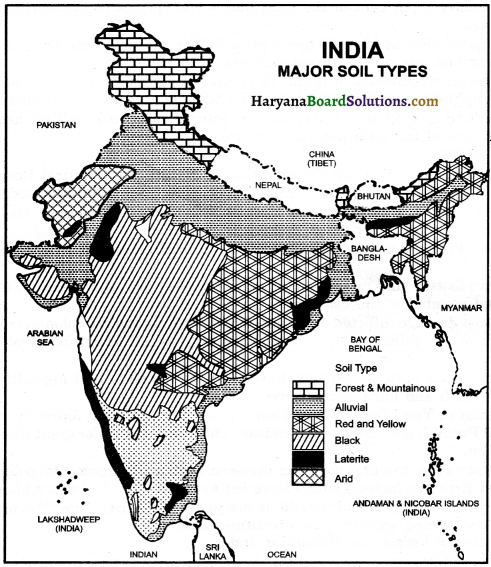
Give a brief account of the major soil types found in India.
OR
Write an essay on classification of soils in India.
OR
Write a note on Black Soil.
OR
Mention some important features of Arid Soil.
OR
Write a note on forest Soil and Laterite soils.
Answer:
Major types of soils and their characteristics – The main types of the soils in India are the following :
1. Alluvial Soils:
Alluvial Soil is the most widely spread and important soil in India. It is spread over a vast area of the northern plains, beginning from the Punjab in the west to the Brahmaputra Valley in the east. As a whole, these soils are very fertile. Mostly, these soils contain adequate proportion of potash, phosphoric acid and lime. This soil contains adequate quantity of humus. On the basis of its age, alluvial soil is divided into two parts –
- Khadar (new alluvial)
- Bangar (Old Alluvial).
2. Black Soil:
Black soils are black in colour and are also known as Regur Soils. These soils cover the plateaus of Maharashtra, Saurashtra, Malwa, Madhya Pradesh, Chhattisgarh, and extend in the South-East direction along the Godavari and the Krishna Valleys. This soil is ideal for growing cotton, tobacco, oil seeds and sugarcane. This soil is formed by weathering of volcanic (Basalt) rocks formed by the Deccan lava.
These soils are made up of fine clayey materials. It is well known for its capacity to hold moisture and is rich in soil nutrients, such as calcium carbonate, potash, magnesium and lime, but poor in phosphoric contents. Development of deep cracks during hot weather helps in the proper aeration of the soil. These soils are sticky when wet and difficult to work on, unless tilled immediately after the first shower or during the pre-monsoon period.
![]()
3. Laterite Soils:
Laterite soils are commonly found in the hilly areas. Such soils are found in Karnataka, Kerala, Tamil Nadu, Madhya Pradesh, and the hilly areas of Odisha and Assam. They develop in areas with high temperature and heavy rainfall. These are a result of intense leaching, owing to heavy rains.
These soils are acidic in nature. Humus content of the soil is low because most of the micro-organisms particularly, the decomposers like bacteria, get destroyed due to high temperature. Due to lack of nitrogen, potassium and organic elements, the laterite soils lack fertility and are not suitable for cultivation, but when the soils are manured and irrigated, some crops like tea and coffee can be cultivated very well in them.
4. Forest Soil:
These soils are formed due to mechanical weathering, caused by snow, rain, temperature variation etc. These soils are found in the hilly region. These soils are very rich in humus, but are deficient in potash, phosphorus and lime. These soils are especially suitable for plantation of tea, coffee, spices and tropical fruits. These soils are heterogenous in nature and their characteristics change with mountain environment and altitude. These soils are loamy and silty in valley sides, and coarsely grained in the upper slopes. They are acidic, with low humus content in the snow covered areas. They are fertile in the lower parts of the valleys.
5. Arid Soil:
This soil is found in Rajasthan, Punjab and Haryana. These soils range from
red to brown in colour. These soils are mostly covered with sand particles and are infertile, but if irrigation facilities are available, they can prove to be quite useful, as is the case with Western Rajasthan. Other features are as follows : ‘ Raj’ 2015
- These soils contain considerable amount of soluble salts.
- These soils contain low percentage of organic matter due to dry climate and absence of vegetation.
- These soils are alkaline in nature, as there is no rainfall to wash soluble salts.
- The lower horizon of the soil is occupied by ‘Kankar’ because of the increasing calcium content, downwards. The ‘Kankar’ layer formations in the bottom horizons, restrict the infiltration of water.
- These soils are infertile, but with irrigation and fertilizers, the drought-resistant and salt-tolerent dry crops such as barley, cotton, wheat, millets, maize, pulses etc. can be grown.
6. Red and Yellow Soil:
These soils are found in parts of Odisha, Chhattisgarh, Southern parts of the middle Ganga Plain and along the Piedmont zone of the Western Ghats. These soils are deficient in phosporic acid and nitrogenous materials, but are rich in potash. Crops grown in these types of soils are cultivated with the use of fertilizers. Crops like wheat, rice, cotton, pulses are grown in these soils.
Question 4.
Explain the major types of soil erosion prevailing in India. Also explain some methods which can be used for soil conservation. ‘Raj. Hoard 2017
Answer:
Major Types of Soil Erosion prevailing in India :
(A) Water Erosion:
Water is a powerful agent of soil erosion. Following are the major types of erosion caused by water –
(i) Sheet Erosion:
When the top layer of the soil is removed over a large area by running water, it is called sheet erosion.
(ii) Rill Erosion:
This is the second stage of sheet erosion. If erosion continues unchecked for a sufficient time, rills or small finger-shaped grooves, which are a few centimetres in depth, may develop on the landscape.
Over a period of time, the fine rills increase in number and also become deeper and wider, and resemble the twigs, branches and trunk of a tree. This is called rill erosion.
![]()
(iii) Gully Erosion:
This is the third stage of sheet erosion. With further erosion of the soil, the rills may deepen and become enlarged, and are ultimately turned into gullies. The main cause of gully erosion is the removal of vegetation, particularly of trees with their wide¬spread binding roots. Gullies cut up agricultural land and the entire area may be turned into a bad land. It is also responsible for the formation of ravines.
(B) Wind Erosion:
When the wind blows the loose soil off flat or sloping land, this erosion is called wind erosion.
Measures for Soil Conservation:
(i) Crop Rotation: If the same crop is sown in the same field, year after year, this consumes certain nutrients from the soil, making it infertile. Crop rotation can check this type of erosion.
(ii) Terrace Cultivation: Steps can be cut out on the slopes to make terraces. This restricts erosion in the hilly areas.
(iii) Strip Cropping: Large fields can be divided into strips. Strips of grass are left to
grow between the crops. This breaks the force of the wind.
(iv) Contour Ploughing: Ploughing along the contour lines can slow down the flow of water down the slopes.
(v) Shelter Belts: Planting lines of trees to create shelter also works to break the force ‘ of the wind.
Map Work
Question 1.
On an outline map of India, show the following :
(a) Alluvial Soil
(b) Black Soil
(c) Red and Yellow Soil
(d) Laterite Soil
(e) Arid Soil
(f) Forest and Mountainous soils.
Answer: