Haryana State Board HBSE 6th Class Social Science Solutions Geography Chapter 2 Globe: Latitudes and Longitudes Textbook Exercise Questions and Answers.
Haryana Board 6th Class Social Science Solutions Geography Chapter 2 Globe: Latitudes and Longitudes
HBSE 6th Class Geography Globe: Latitudes and Longitudes Textbook Questions and Answers
Class 6 Geography Chapter 2 Globe Latitudes And Longitudes HBSE Question 1.
Answer the following questions briefly:
(а) What is the true shape of the earth?
Answer:
The true shape of the earth is a sphere flattened at the poles such a shape is called a geoid.
(b) What is a globe?
Answer:
Globe is a true model (miniature form) of the earth.
(c) What is the latitudinal value of the Tropic of Cancer?
Answer:
The latitudinal value of the Tropic of Cancer is 231/4° N.
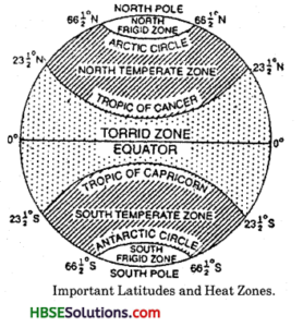
(d) What are the three heat zones of the Earth?
Answer:
The three heat zones of the earth are :
- Torrid zone
- Temperate zone
- Frigid zone.
(e) What are parallels of latitude and meridians of latitude?
Answer:
Parallels of latitude: All parallel circles from the equator up to the poles are called parallels of latitude.
Meridians of latitude : The lines of reference running from the North Pole to South Pole are called meridians of longitude.
(f) Why does the torrid zone receive maximum amount of heat?
Answer:
Torrid zone receives the maximum amount of heat because this is located between the Tropic of Cancer and the Tropic of Capricorn in 231/2° N to 23(4° S. The rays of the sun fall vertically on this region.
(g) Why is it 5.30 p.m in India and 12:00 noon in London?
Answer:
The Earth rotates about 360° in 24 hours, i.e., 1° in 4 minutes. Each degree of longitudes corresponds to a difference of four minutes. The standard meridian of India is 82° 30’E, and that of London is 0°. This means a difference of 4 minutes x 82.5 = 330= minutes = 5.5 hours. So when it is 12:00 noon in London, it is 5.30 p.m in India.
![]()
Globe Latitudes And Longitude Class 6 Notes HBSE Question 2.
Tick the correct answers:
(а) The value of the prime meridian is:
(i) 90°
(ii) 0°
(iii) 60°
Answer:
(ii) 0°
(b) The frigid zone lies near:
(i) the Poles
(ii) the Equator
(iii) the Tropic of Cancer
Answer:
(i) the Poles
(c) The total number of longitudes are:
(i) 360°
(ii) 180°
(iii) 90°
Answer:
(i) 360°
(d) The Antarctic circle is located in:
(i) the Northern hemisphere
(ii) the Southern hemisphere
(iii) the Eastern hemisphere
Answer:
(ii) the Southern hemisphere
(e) Grid is a network of:
(i) parallels of latitudes and meridians of longitudes
(ii) the Tropic of Cancer and the Tropic of Capricorn
(iii) the North Pole and the South Pole
Answer:
(i) parallels of latitudes and meridians of longitudes
Globe Latitudes And Longitudes Class 6 Questions And Answers HBSE Question 3.
Fill in the blanks:
- The Tropic of Capricorn is located at _________.
- The Standard Meridian of India is _________.
- The 0° Meridian is also known as _________.
- The distance between the longitudes decreases towards _________.
- The Arctic Circle is located in the _________ hemisphere.
Answer:
- 23 1/2° S
- 821/2°E
- Prime Meridian
- Poles
- Northern.
THINGS TO DO
HBSE 6th Class Social Science Globe: Latitudes and Longitudes Question 4.
Draw a diagram of the globe showing the earth’s axis, the Equator, Tropics of Cancer and Capricorn, Arctic Circle and Antarctic Circle.
Answer:
HBSE 6th Class Geography Globe: Latitudes and Longitudes Important Questions and Answers
Very Short Answer Type Questions
Question 1.
What are the two halves of the earth known as?
Answer:
The northern half of the earth is known as northern hemisphere and the southern half of the sun is known as southern hemisphere.
Question 2.
Why is equator considered as an important reference point to locate places to the earth?
Answer:
The equator is considered as an important reference point to locate places on the earth because equator divides the earth into equal halves.
![]()
Question 3.
Give reason : Torrid Zone receives the maximum heat.
Answer:
Torrid Zone receives the maximum heat because the mid-day sun is exactly overhead at least once a year on all latitudes in between the Tropic of Cancer and the Tropic of Capricorn.
Question 4.
Which imaginary line divides the earth into two halves?
Answer:
The equator divides the earth into two equal halves.
Question 5.
Where does the Temperate Zone lie?
Answer:
The Temperate Zone lies between Tropic of Cancer and Arctic Circle in Northern Hemisphere and Tropic of Capricorn and Antarctic Circle in Southern Hemisphere.
Short Answer Type Questions
Question 1.
How are meridians numbered?
Answer:
The meridian which passes through Greenwich, i.e., Prime Meridian is valued as 0° longitude and from it we count 180° eastward as well as 180° westward.
Question 2.
A day and night cricket match between India and England had started at 2 p.m in London. At what time would the match begin in India? How would you calculate?
Answer:
The match would begin in India at 7:30 p.m. India located east of Greenwich at 82°30′ E is 5 hours 30 minutes ahead of GMT. So it will be 7:30 p.m in India when it is 2:00 p.m in London.
Question 3.
What are heat zones?
Answer:
Heat zones are the different zones of the earth, where the sun’s rays fall differently, this causing different climate patterns these zones are called the Torrid Zone, the two Temperate Zones, and the two Frigid Zones. The Torrid Zone in very hot since the sun shines overhead here. The Temperate Zones maintain a moderate climate and the Frigid Zones are extremely cold.
![]()
Question 4.
Write four features of globe?
Answer:
- Globe is a true model (miniature form) of the earth.
- Globes may be of varying size and type – big ones, which cannot be carried easily, small pocket globes, and globe- like balloons which can be inflated and are handy and carried with ease.
Long Answer Type Questions
Question 1.
What is the difference between the local time and the standard time?
Answer:
When the sun reaches the highest point in the sky, while crossing the meridian of any places it is noon (12.00). At some places watches are adjusted according to this time. It will be known as local time. Places having the same meridian of longitude have the same local time.
Standard Time : In countries with a large east-west extent, the variation in local time is very great. It creates confusion over train timings, flight timings etc. To solve this problem, the local time of a particular meridian is taken as the standard time for entire region of the country.
Question 2.
Which are the important parallels of latitude?
Answer:
Besides the equator, there are four other important parallels of latitude which have been given special names :
1. Tropic of Cancer : It is an important parallel in the Northern Hemisphere. It is an angular distance of 231/2° N (23° 30′ N) from the equator. It is important because it makes the northernmost limit of overhead sun.
2. Tropic of Capricorn : It makes the southernmost of overhead sun. Its angular distance is 23° 30′ S from the equator.
3. Arctic Circle (66V6°N) : It lies at a distance of 66°30′ N of the equator. It is also important because on this parallel we have 24 hours daylight on 21st June.
4. Antarctic Circle (66°30’S) : It is also an important parallel because on this we have 24 hours daylight on 22nd December.
Question 3.
What is Standard Time? What is the need for the Standard time?
Answer:
The local time of standard meridian of a country is called standard time. The different meridians have different local times. This is bound to create problems for people to function. For example, train time, flight schedules which cross several longitudes will be difficult to prepare. For example, There will be a difference of about 1 hour and 45 minutes in the local times Dwarka in Gujarat and Dibrugarh in Assam. To maintain uniformity in time throughout the country the standard time is needed. In India 82° 30′ E meridian is considered for the purpose of standard time. The local times as per this meridian is followed all over the country.
![]()
Globe: Latitudes and Longitudes Class 6 HBSE Notes
- Latitude : The angular distance of a place north or south of the equator.
- Longitude : The angular distance of a place east or west of the Prime Meridian.
- Globe : Globe is a man-made model of the earth.
- Equator : The imaginary line of 0° latitude encircling the earth and passing the half way between the North and South Pole.
- Tropic of Capricorn : It is the parallel of 231/2° S in Southern Hemisphere. .
- Tropic of Cancer : It is the parallel of 231/2° N in the Northern Hemisphere.
- Torrid Zone : The region that receives the maximum amount of heat throughout the year is Torrid Zone.
- Prime Meridian: The longitude running through the Greenwich near London was first chosen as Prime Meridian.
- Local Time : It is the time by the position of the sun at noon of a place.
- Standard Time : Time fixed at Central Meridian which is considered the Standard Time of that country.
- Heat Zones: Heat zones are the different zones of the earth, where the sun’s rays fall differently, thus causing different climate patterns.
- Standard Time : Standard time of a country or region is the time regarded as a standard for that place, despite the fact that there exists time difference geographically across that region.