Haryana State Board HBSE 10th Class Social Science Solutions Geography Chapter 7 Lifelines of National Economy Textbook Exercise Questions and Answers.
Haryana Board 10th Class Social Science Solutions Geography Chapter 7 Lifelines of National Economy
HBSE 10th Class Geography Lifelines of National Economy Intext Questions and Answers
Textbook (Page No. 80)
Lifelines of National Economy Class 10 Solutions HBSE Geography Question 1.
Find out places linked by the National Highway 2 and 3.
Answer:
Places linked by the National Highway 2 – Delhi-Faridabad-Ballabhgarh-Palwal- Kosi-Mathura-Agra-Firozabad-Etawah-Kanpur-Varanasi-Mohania-Aurangabad-Champaran- Dumri-Sirsa-Asansol-Raniganj-Srirampur-Kolkata.
Places linked by the National Highway 3 – Agra-Dholpur-Muraina-Gwalior-Shivpuri- Guna-Indore-Dhule-N asik-Thane-Mumbai.
Textbook (Page No. 82)
Lifelines of National Economy Chapter 7 HBSE 10th Class Geography Question 2.
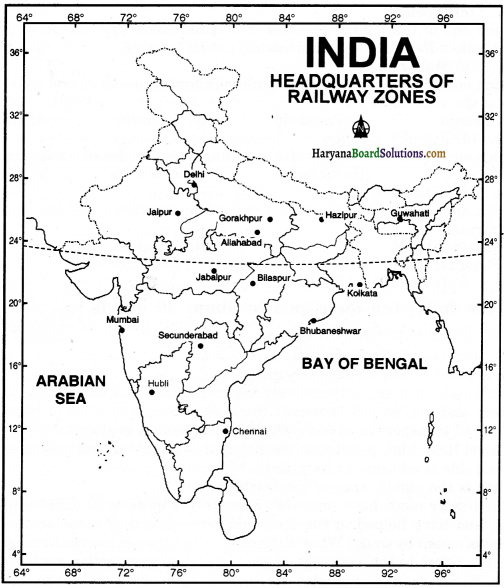
Find out the current Railway zones and their headquarters Also locate the head quarters of Railway zones on the map of India.
Answer:
| Railway Zones | Headquarters |
| 1. Northern Railway Zone | New Delhi |
| 2. Southern Railway Zone | Chennai |
| 3. Western Railway Zone | Mumbai (Church gate) |
| 4. Central Railway Zone | Mumbai (C.S.T.) |
| 5. Eastern Railway Zone | Kolkata |
| 6. South-Eastern Railway Zone | Kolkata |
| 7. North-Eastern Railway Zone | Gorakhpur |
| 8. South-Central Railway Zone | Secunderabad |
| 9. North-East Frontier Railway Zone | Maligaon (Guwahati) |
| 10. East-Central Railway Zone | Hajipur |
| 11. North-Western Railway Zone | Jaipur |
| 12. North-Central Railway Zone | Allahabad |
| 13. Eastern Coast Railway Zone | Bhubaneshwar |
| 14. South-Western Railway Zone | Hubli |
| 15. West-Central Railway Zone | Jabalpur |
| 16. South-East Central Railway | Bilaspur |
| 17. Zone Metro Railway Zone | Kolkata |
Textbook (Page No. 86)
Chapter 7 Lifelines of National Economy HBSE 10th Class Geography Question 3.
Why is air-travel preferred in the north-eastern state?
Answer:
The relief of north-eastern part of the country is marked with the presence of big rivers, dissected relief, dense forests, frequent floods and international frontiers etc. Air travel can cover these very difficult terrains with great ease thus, it is preferred in the states of north-eastern parts of India.
![]()
Question 4.
Find out the names of the countries connected by Indian Airlines.
Answer:
Nepal, Bhutan, Bangladesh, Sri Lanka, Maldives, Qatar, UAE, Malaysia, Thailand, Pakistan, Singapore, Kuwait and other main countries.
HBSE 10th Class Geography Lifelines of National Economy Textbook Questions and Answers
1. Multiple Choice Questions :
(i) Which two of the following extreme locations are connected by the east-west corridor ?
(a) Mumbai and Nagpur
(b) Silchar and Porbandar
(c) Mumbai and Kolkata
(d) Nagpur and Siliguri.
Answer:
(b) Silchar and Porbandar.
(ii) Which mode of transportation reduces trans-shipment losses and delays ?
(a) Railways
(b) Roadways
(c) Pipeline
(d) Waterways.
Answer:
(c) Pipeline.
(iii) Which one of the following states is not^connected with the H.V.J. pipeline ?
(a) Madhya Pradesh
(b) Maharashtra
(c) Gujarat
(d) Uttar Pradesh.
Answer:
(b) Maharashtra.
![]()
(iv) Which one of the following ports is the deepest land-locked and well protected port along the east coast ?
(a) Chennai
(b)Paradwip
(c) Tuticorin
(d) Vishakhapatnam.
Answer:
(d) Vishakhapatnam.
(v) Which one of the following is the most important modes of transporation in India ?
(a) Pipeline
(b) Railways
(c) Roadways
(d) Airways.
Answer:
(c) Roadways.
(vi) Which one of the following terms is used to describe trade between two or more countries ?
(a) Internal trade
(b) International trade
(c) External trade
(d) Local trade.
Answer:
(b) International Trade.
2. Answer the following questions in about 30 words :
(i) State any three merits of roadways.
Answer:
(i) Construction cost of roads is very low.
(ii) Roads provide door-to-door services.
(iii) Roads can traverse comparatively more dissected and undulating topography.
(ii) Where and why is rail transport the most convenient mode of transportation?
Answer:
The rail transport in plains is the most convenient mode of transportation because of their vast level land, high population density and rich agricultural resources, that provide the most favourable conditions to its growth.
(iii) What is the significance of the border roads?
Answer:
The border roads have improved accessibility in areas of difficult terrain, defence preparedness, and have helped in the economic development of these areas.
![]()
(iv) What is meant by trade? What is the difference between international and local trade?
Answer:
Trade refers to the exchange of goods between two parties, such as people, states
and countries. When trade is conducted between villages, cities and towns of a country, it is called local trade. When the goods are exported or imported from one country to another country, it is called international trade.
3. Answer the following questions in about 120 words :
(i) Why are the modes of transportation and communication called the lifelines of a nation and its economy?
Answer:
(a) We use different materials and services in our daily life. Some of these are available in our immediate surroundings, while other requirements are met by bringing things from other places.
(b) Goods and services do not move from supply locales to demand locales on their own. They need modes of transportation.
(c) The pace of development of a country depends upon the production of goods and services, as well as their movement over space.
(d) Transport has been able to achieve this with the help of an equally developed communication system.
(e) Railways, airways, waterways, newspapers, radio, television, cinema and internet, etc. have been contributing towards socio-economic progress in many ways.
(f) The trades from local to international levels have added to the vitality of the economy of a nation.
(g) It has enriched our life and added facilities for the comforts of life.
Thus, we can say that a dense and|efficient network of transport and communication is a pre-requisite for local, national and global trade of today, and it is a lifeline of national economy. W
(ii) Write a note on the changing nature of the international trade in the last fifteen years.
Answer:
Changing nature of India’s International Trade: International trade has undergone a great change in the last fifteen years. We can understand it through the following points:
(a) Exchange of goods and commodities has been superseded by the exchange of information
and knowledge.
(b) India has emerged as a software giant in the world and it is earning large foreign exchange through the export of information technology.
(c) The composition of commodities in International Trade of India has been undergoing a change over the years. The share of agriculture and allied products has declined whereas share of petroleum and crude products and other commodities has increased.
(d) India exports agricultural and allied products, ores and minerals, gems and jewellery, chemical and allied products, engineering goods, etc. whose share has been increasing over the last few years.
(e) India imports petroleum and petroleum products, pearls and precious stones, gold and silver, chemicals, coal, coke and briquettes, and other unclassified items etc.
(f) Tourism in India has grown over the last three decades. Foreign tourists’ arrival in the country has witnessed an increase of about 23.5%.
(g) India is having increasing trade relations with the USA, Canada, Australia, Japan, Russia, Europe and the major oil-producing countries, other than with Great Britain.
(h) India has also been exporting manufactured goods to other countries.
(i) India’s trade relations with the SAARC region countries are also on an increase.
![]()
Knowledge Basket
Quiz Drive
1. Northern terminal of the North-South corridor.
2. The name of National Highway No. 2.
3. The headquarters of the southern railway zone.
4. The rail gauge with a track width of 1.676 m.
5. The southern terminal of National Highway No. 7.
6. A Riverine Port.
7. Busiest railway junction in Northern India.
Answer:
Start your search vertically, horizontally or diagonally and reach various destinations across the country!

- Srinagar
- Shershah Suri Marg
- Chennai
- Broad Gauge
- Kanyakumari
- Kolkata
- Mughal Sarai.
![]()
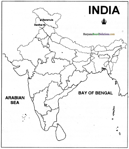
Railway line has been extended from Banihal to Baramula in the Kashmir Velley. Locate these two towns on the map of India. (Page 84)
Answer: