Haryana State Board HBSE 10th Class Social Science Important Questions Geography Chapter 7 Lifelines of National Economy Important Questions and Answers.
Haryana Board 10th Class Social Science Important Questions Geography Chapter 7 Lifelines of National Economy
Multiple Choice Questions
Lifelines Of National Economy Important Questions HBSE 10th Class Question 1.
North-South Corridor connects which of the following?
(a) Patna-Kochi
(b) Srinagar-Kanyakumari
(c) Delhi-Chennai
(d) Shimla-Bengaluru.
Answer:
(b) Srinagar-Kanyakumari
Class 10 Geography Chapter 7 Important Questions HBSE Question 2.
What is the full form of NHAI?
(a) Northern Himalayan Region Airport Investigation Authority
(b) National Hospitals Authority of India
(c) National Highest Authority of India
(d) National Highway Authority of India.
Answer:
(d) National Highway Authority of India.
Lifelines Of National Economy Class 10 Questions And Answers HBSE Question 3.
Who builds and maintains the National Highways?
(a) National Government
(b) State Government
(c) Village Panchayat
(d) District-level governing body.
Answer:
(a) National Government
Lifelines Of National Economy Class 10 Important Questions And Answers HBSE
Question 4.
Which of the following is the cheapest modes of transport?
(a) Railways
(b) Pipelines
(c) Waterways
(d) Roadways.
Answer:
(c) Waterways
Lifelines Of National Economy Class 10 Notes Questions And Answers HBSE Question 5.
National Higway No. 8 connects:
(a) Chennai-Kolkata
(b) Delhi-Bengaluru
(c) Mumbai-Chennai
(d) Delhi-Mumbai.
Answer:
(d) Delhi-Mumbai.
Question 6.
Which one of the following groups of cities is connected by the National Highway No. 7?
(a) Delhi-Amritsar
(b) Delhi-Kolkata
(c) Delhi-Mumbai
(d) Varanasi-Kanyakumari.
Answer:
(d) Varanasi-Kanyakumari.
![]()
Question 7
is the longest National Highway.
(a) NH – 5
(b) NH-2
(c) NH-7
(d) NH-1.
Answer:
(c) NH-7
Question 8.
The first train steamed off from Bombay to Thane in which year
(a) 1853
(b) 1860
(c) 1863
(d) 1873.
Answer:
(a) 1853
Question 9.
How many major sea ports are there in India?
(a) 12
(b) 14
(c) 15
(d) 20
Answer:
(a) 12
Question 10.
Kandla Seaport is an example of:
(a) Tidal Port
(b) Hinterland
(c) Artificial Port
(d) National Highway.
Answer:
(a) Tidal Port
Question 11.
The new seaport of Haldia is located near which city?
(a) Chennai
(b) Kandla
(c) Mumbai
(d) Kolkata.
Answer:
(d) Kolkata.
Question 12
is the oldest artificial seaport of the country.
(a) Kolkata
(b) Vishakhapatnam
(c) Chennai
(d) Haldia.
Answer:
(c) Chennai
![]()
Question 13.
is the costliest means of transport.
(a) Roadways
(b) Airways
(c) Waterways
(d) Railways.
Answer:
(b) Airways
Question 14.
Netaji Subhash Chandra Bose Airport is situated in
(a) Punjab
(b) West Bengal
(c) Orissa
(d) Maharashtra.
Answer:
(b) West Bengal
Question 15.
Where is Chhatrapati Shivaji Airport located ?
(a) Mumbai
(b) Kolkata
(c) Delhi
(d) Chennai.
Answer:
(a) Mumbai
Question 16.
Hfhich of the following is not a means of communication ?
(a) Press
(b) Radio
(c) Railways
(d) Films.
Answer:
(c) Railways
Question 17.
The first class mail includes which of the followings ?
(a) Book packets
(b) Registered newspapers
(c) Envelopes and cards
(d) Periodicals and journals.
Answer:
(c) Envelopes and cards
![]()
Question 18.
In which language are the maximum number of newspapers published in India ?
(a) Hindi
(b) English
(c) Malyalam
(d) Marathi.
Answer:
(a) Hindi
Question 19.
Which country has the largest telecom network in Asia ?
(a) India
(b) China
(c) Japan
(d) Sri Lanka.
Answer:
(a) India
Question 20
is considered as the economic barometer of the country.
(a) State level trade
(b) Local trade
(c) International trade
(d) Internal trade.
Answer:
(c) International trade
Fill in the blanks
1. Movements of these …………. and …………. can be over three important of our earth.
Answer:
goods, services, domains.
2. India has one of the ………….. road networks in the world.
Answer:
largest.
3. The historical …………. marg is called national highway no
Answer:
Sher-Shah-Suri, 1.
4. Railways are the principal mode of ………… for …………. and …………. in India.
Answer:
transportation, freight, passengers.
5. ……………. transport network is a new arrival on the transportation map of …………..
Answer:
biggest, harbour.
6. Mumbai is the ………….. port with a spacious natural and well-sheltered …………
Answer:
biggest, harbour.
7. The air transport was nationalised in …………
Answer:
1953.
![]()
8. India has the …………. telecom network in
Answer:
largest, Asia.
Match the following
Match Column A with Column B:
| Column-A | Column-B |
| 1. Sher-Shah-Suri Marg | (a) Jaipur |
| 2. North-Western Railway | (b) 1.676 mt |
| 3. Broad gauge | (c) Allahabad-Haldiya |
| 4. N.W. No. 1 | (d) Kandla |
| 5. Deendayal Part | (e) NH-1. |
Answer:
| Column-A | Column-B |
| 1. Sher-Shah-Suri Marg | 1. (e) NH-1. |
| 2. North-Western Railway | 2. (a) Jaipur |
| 3. Broad gauge | 3. (b) 1.676 mt |
| 4. N.W. No. 1 | 4. (c) Allahabad-Haldiya |
| 5. Deendayal Part | 5. (d) Kandla |
Very Short Answer Type Questions
Question 1.
Which are known as lifelines of the national economy?
Answer:
Transportation, Communication, International Trade and Tourism are known as lifelines of the National Economy.
Question 2.
What is transport?
Answer:
An action of carrying persons and goods from one place to another place is called transport.
Question 3.
Who is a trader?
Answer:
A person who makes the products reachable to the consumers by transportation is called a trader.
Question 4.
Which are the three modes of transport?
Answer:
- Land
- Water
- Air
Question 6.
What has changed this wide world into a big village today?
Answer:
Today, the world has been converted into a big village with the help of efficient and fast-moving transport.
Question 6.
State three types of land transport.
Answer:
- Roadways
- Railways
- Pipelines.
Question 7.
State two types of water transport.
Answer:
(i) Inland waterways
(ii) Overseas waterways.
![]()
Question 8.
State two types of Air Transport.
Answer:
(i) Domestic Airways
(ii) International Airways.
Question 9.
According to their capacity, what are the six categories of roads in India?
Answer:
- Golden quadrilateral super highways
- National Highways
- State Highways,
- District Roads
- Other roads
- Border roads.
Question 10.
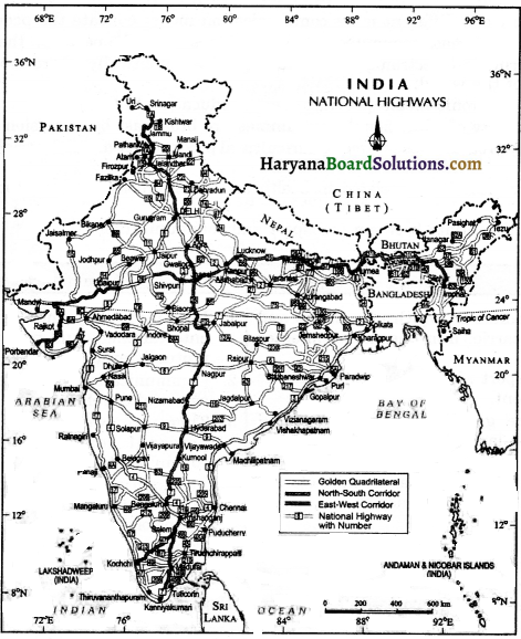
What is golden quadrilateral?
Answer:
A golden quadrilateral is a network of major roads, linking Delhi-Kolkata-Chennai- Mumbai by six lane super highways.
Question 11.
Under the golden quadrilateral, super highways project, what are the two corridors? Name them.
Answer:
- North-South Corridor
- East-West Corridor.
Question 12.
What is the aim of constructing Golden Quadrilateral Super Highways?
Answer:
The major objective of Golden Quadrilateral Super Highways is to reduce the time and distance between the megacities of India.
Question 13.
Which agency constructs and maintains the National Highways?
Answer:
Central Public Works Department (CPWD).
Question 14.
What is the name of the major National Highway 01?
Answer:
Shershah Suri Marg (National Highway No.l), between Delhi and Amritsar.
Question 15.
Name the places linked by National Highway No. 2.
Answer:
Kolkata-Asansol-Dhanbad-Varanasi-Allahabad-Kanpur-Agra-Delhi.
![]()
Question 16.
Name the National Highway that links almost all the places of Rajasthan.
Answer:
National Highway No. 15.
Question 17.
What are State Highways?
Answer:
Roads, linking a state capital with different district headquarters are known as State Highways.
Question 18.
What are district roads?
Answer:
These roads connect the district headquarters with other places of the district.
Question 19.
Explain the Pradhan Mantri Grameen Sadak Yojana.
Answer:
Under this scheme, special provisions are made, so that every village in the country is linked to a major town in the country by an all-season motorable road.
Question 20.
What are border roads?
Answer:
These roads are constructed in the border areas of the country. Border roads organisation, a government of India undertaking, watches over these projects.
Question 21.
What is road density?
Answer:
The length of roads per 100 sq km. of area is known as the density of roads.
Question 22.
What is the average road density of India?
Answer:
142.68 km. per 100 sq km (2011).
Question 23.
When and where did the first train run in India?
Answer:
The first train steamed off from Mumbai to Thane in 1853.
Question 24.
Which are the three rail gauges of India?
Answer:
- Broad gauge
- Metre gauge
- Narrow gauge.
Question 25.
What are the uses of pipelines?
Answer:
Pipelines are used for transporting crude oil, petroleum products and natural gas, from production area, to refineries, fertilizer factories and thermal power plants.
![]()
Question 26.
What is the total length of inland navigational waterways in India?
Answer:
14,500 km.
Question 27.
Name the two navigational rivers of India.
Answer:
(i) Ganga
(ii) the Brahmaputra.
Question 28.
How many major seaports are there in India?
Answer:
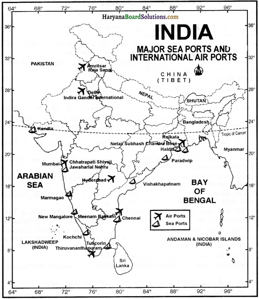
There are 12 major seaports in India.
Question 29.
Name the two main seaports of the western coast of India?
Answer:
(i) Kandla
(ii) Mumbai.
Question 30.
Name the two main seaports of the Eastern coast of India?
Answer:
(i) Chennai
(ii) Kolkata.
Question 31.
What is the name of the biggest seaport of India?
Answer:
Mumbai Seaport.
Question 32.
What is the name of the premier iron-ore exporting seaport?
Answer:
Marmagao Seaport (Goa).
Question 33.
What is the name of the inland riverine port in India?
Answer:
Kolkata Port.
Question 34.
Why was Haldia Port developed?
Answer:
Haldia port was developed to relieve growing pressure on the Kolkata Port.
Question 35.
What is the name of the fastest, the most comfortable and the most prestigious mode of transport?
Answer:
Airways.
Question 36.
Write the name of the air services operating in India.
Answer:
- Indian Airlines
- Air India
- Pawan Hans Helicopters Ltd.
- Private Scheduled Airlines.
![]()
Question 37.
Write the names of the major modes of communication.
Answer:
- Television
- Radio
- Press
- Films etc.
Question 38.
Write the name of the authority that certifies both Indian and Foreign films?
Answer:
Central Board of Film Certification.
Question 39.
What is Trade?
Answer:
The exchange of goods among people, states and countries is called trade.
Question 40.
What is a Market?
Answer:
The market is the place where the exchange of goods takes place.
Question 41.
What is International Trade?
Answer:
Trade between two countries is called international trade.
Question 42.
What is local trade?
Answer:
Local trade is carried in cities, towns and villages.
Question 43.
What is state-level trade?
Answer:
A state-level trade is carried out between two or more states.
Question 44.
Which is known as the economic barometer for a country?
Answer:
International Trade.
Question 45.
What is trade balance?
Answer:
The trade balance of a country is the difference between its exports and imports.
Question 46.
What is a favourable trade balance?
Answer:
When the value of exports exceeds the value of imports, it is called a favourable trade balance.
![]()
Question 47.
What is an unfavourable trade balance?
Answer:
If the value of imports exceeds the value of exports, it is termed as unfavourable trade balance.
Question 48.
What is Tourism?
Answer:
Journey from one place to another place, to see and understand the culture, naturally beautiful places and landscapes, is called tourism.
Question 49.
List three factors which influence the distribution pattern oflndian railway network.
Answer:
- Physiographic
- Economic
- Administrative factors,
Question 50.
When was air transport nationalised in India?
Answer:
In 1953.
Question 51.
List any two benefits of tourism.
Answer:
(i) Promotes national integration, and
(ii) Provides support to local handicrafts and cultural pursuits.
Short Answer Type Questions-I
Question 1.
‘Transport, Communication and Trade are complementary to each other’. Explain.
Answer:
The movement of goods and services from their supply locations to demand locations necessitates the need for transport. Traders make the products come to the consumers by transportation. Today, the world has been converted into a large village with the help of efficient and fast moving transport. This advancement of transport has been achieved with the help of equally developed communication. Thus, we can say that transport, communication and trade are complementary to each other.
Question 2.
What do you know about Golden Quadrilateral Super Highways?
Answer:
Golden Quadrilateral Super Highways is a major road development project launched by the Central Government, linking Delhi-Kolkata-Chennai-Mumbai by six-lane super highways. The main objective of these super highways is to reduce the time and distance between the mega cities of India. This project is being implemented by the National Highway Authority of India.
The two corridors constructed under this project are –
(i) The North-South Corridor, linking Srinagar and Kanyakumari
(ii) The East-West Corridor, linking Silchar and Porbandar
![]() .
.
Question 3.
What do you mean by National Highways?
Answer:
These are the broad roads, connecting all states and capitals. National Highways link extreme parts of the country. These are the primary road systems and are constructed and maintained by Central Public Works Department. Example-National Highway No.l.
Question 4.
Differentiate between National Highways and State Highways.
Answer:
National Highways:
- These roads are constructed and maintained by the central government.
- These connect one state to other states
- These are of national importance.
State Highways:
- These roads are constructed and maintained by the state government.
- These connect state capitals with district headquarters.
- These are of state importance.
Question 5.
How are the roads classified on the basis of type of material used for their construction?
Answer:
Roads can be classified into two categories on the basis of material used for their construction:
(i) Metalled Roads: They are made of cement, concrete or coaltar, and are also called Pucca roads.
(ii) Unmetalled Roads: They are called Kuchha roads and go out of use in the rainy season.
Question 6.
What do you know about Border Roads Organisation?
OR
Explain the importance of Border Roads for India.
Answer:
Border Roads Organisation is an organisation which constructs and maintains roads in the bordering areas of the country. This organisation was set up in 1960, for the development of the roads of strategic importance in the Northern and North-Eastern Border areas.
Question 7.
What are the different regions of our country that are unfavourable to lay railway lines?
Answer:
(i) The Himalayan mountainous regions are unfavourable for laying railway tracks due to high relief, sparse population and lack of economic opportunities.
(ii) It is also difficult to lay railway lines on the sandy plain of western Rajasthan, swamps of Gujarat, forested tracks of Madhya Pradesh, Chhattisgarh, Orissa and Jharkhand.
![]()
Question 8.
Name the major waterways of India.
Answer:
- National Waterways No. 1. : The Ganga river between Allahabad and Haldia (1620 km.).
- National Waterways No. 2 : The Brahmaputra river between Sadiya and Dhubri (891 km.).
- National Waterways No. 3 : The West-coast Canal in Kerala (Kottapurma-Kollam, Udyogamandal and Champakkara Canals (205 km.).
- National Waterways No. 4 : Stretches of Godavari and Krishna rivers along with Kakinada-Puducherry stretch of canals (1078 km).
- National Waterways No. 5 : River Brahmani along with Matai river, delta channels • of Mahanadi and Brahmani rivers and east coast canal (588 km).
Question 9.
Which is the largest seaport of India? What was the objective of the development of the Jawaharlal Nehru Port?
Answer:
Mumbai is the biggest port of India. The Jawaharlal Nehru Port was planned with a view to decongest the Mumbai port and serve as a hub port for this region.
Question 10.
Name the twelve major ports of India?
Answer:
The twelve major ports are the following:
- Kandla (Gujarat)
- Mumbai (Maharashtra)
- Jawaharlal Nehru Port, Nhava Sheva (Maharashtra)
- Marmagao (Goa),
- New Mangalore (Karnataka)
- Kochi (Kerala)
- Tuticorin (Tamil Nadu)
- Ennore (Tamil Nadu)
- Chennai (Tamil Nadu)
- Vishakhapatnam (Andhra Pradesh)
- Paradwip (Orissa)
- Haldia-Kolkata (West Bengal).
Question 11.
What do you mean by mass communication?
Answer:
The means of communication through which, one can communicate with several people at the same time, is called mass communication.
Radio, television, newspaper etc. are the main sources of mass communication. Mass communication provides entertainment and creates awarness among the people about various national policies and programmes.
Short Answer Type: Questions-II
Question 1.
Classify the different modes of transport.
Answer:
Based on the movement of goods and services in three domains of our earth i.e. land, water and air, the transport can be classified into the following three modes:
(i) Land Transport:
It is divided into three parts-
(a) Roadways
(b) Railways,
(iii) Pipelines.
(ii) Water Transport:
It is divided into two parts –
(a) Inland Waterways
(b) Overseas
(oceanic) Water ways:
(iii) Air Transport:
It is further divided into two parts –
(a) Domestic Airways: Public undertaking and private airlines.
(b) International Airways.
![]()
Question 2.
Roadways are more important than railways. Give reasons. Describe the utility of road transportation.
Answer:
- The greater importance of road transport, as compared to rail transport is rooted in the following reasons :
- Construction cost of roads is much lower than that of railway lines.
- Roads can traverse comparatively more dissected and undulating topography.
- Roads can negotiate higher gradients of slopes, and as such, can traverse mountains, such as the Himalayas.
- Road transport is economical in transportation of few persons and relatively smaller amount of goods over short distances.
- It also provides door-to-door service, thus the cost of loading and unloading is much lower than rail.
- Road transport is also used as a feeder to other modes of transport, such as, they provide a link between railway stations, air and sea ports.
Question 3.
What are the major problems of road transport in India ? (CBSE 2018′
Answer:
The major problems of road transport in India are as the following :
- Keeping in view the volume of traffic, the road network is inadequate.
- Aboult fifty percent roads are unmetalled and become muddy during the rainy season.
- They are highly congested in the cities.
- Most of the bridges and culverts are old and narrow.
Question 4.
Write a note on development of railways in India.
Answer:
Indian railway network is one of the longest in the world. The Indian Railways have been a great integrating force for more than 150 years. The first train started from Mumbai to Thane in 1853, covering a distance of 34 km. As on March 2017-18, spread over a route length of 68,442 km. Broad guage, metre guage and narrow guage are the three rail guages of India. The Indian Railway system has now been reorganized into 16-zones.
Question 5.
The distribution pattern of the Railway network in the country is largely influenced by physiographic and economic factors. Delhi Board)
Answer:
- The northern plains have a dense railway network because
- They have high population density
- Vast level land
- They are rich in agricultural resources.
Mountainous, Marshy, Sandy and forested areas have sparse railway network. It is very difficult to lay railway lines in the sandy plains of western Rajasthan, swamps of Gurarat and forested tracks of Madhya Pradesh. Peminsular plateau though has a difficult terrain, but are very rich in mineral resources. To promote industries and to develop industrial areas. These industrial areas also have good connectivity with routes.
Question 6.
What is the importance of railways in India ?
Answer:
Importance of railways in India are the following :
- Railways are the principal mode of transportation for freight and passengers in India.
- Railways also make it possible to conduct multifarious activities, like business, sightseeing, pilgrimage, along with transportation of goods, over longer distances.
- Railways also provide employment to a huge number of people in the country.
- Railways play a significant role in the integration of the country by bringing different people of different regions together.
Question 7.
India : Railway Track
| Gauge in metres | Route (Km) | Running Track (Km) | Total Track (Km) |
| Broad Gauge (1.676) | 63491 | 89521 | 17560 |
| Metre Gauge (1.000) | 3200 | 3462 | 3775 |
| Narrow Gauge (0.762 and 0.610) | 1751 | 1752 | 1901 |
| Total | 68442 | 94735 | 23236 |
Study the above table carefully and answer the following questions:
(i) What was the total length of railway route in 2017-18?
(ii) How is narrow gauge different from broad gauge?
Answer:
(i) Total length of railway route in 2017-18 was 68442 Km.
(ii)
Narrow Gauge:
Narrow Gauge network has 0.762 and 0.610m width between the rails.
Broad Gauge:
Broad Gauge network has 1.676 m width between the rails.
Question 8.
What are the major problems of Indian Railways?
Answer:
The major problems of Indian Railways are the following:
- Many passengers travel without tickets.
- Thefts and damaging of railway property has not yet stopped completely.
- People stop the trains and pull the chain unnecessarily and this causes heavy damage to the railway.
Railway tracks are very old, that may cause an accident.
Question 9.
What are the benefits of pipeline transport ?
Answer:
The major benefits of pipeline transport are :
- Though the initial cost of laying pipelines is high, yet the running cost is very low.
- Transportation through pipelines rules out delay and transportation losses. Many fertilizer plants and
- thermal power stations are benefitted by the supply of gas through pipelines.
- It maintains a continuous supply of gas and oil.
- The pipes can be laid through difficult terrains, as well as under the sea.
- The far inland location of important refineries like Barauni, Mathura, Panipat, etc. could be thought of only because of the pipelines.
![]()
Question 10.
Mention three important networks of pipeline transportation in the country.
Answer:
Three important networks of pipeline transportation in the country are as following:
(i) Pipeline from oilfield in upper Assam to Kanpur (Uttar Pradesh), via Guwahati, Barauni and Allahabad. It has branches from Barauni to Haldia via Rajbandh, Rajbandh to Mauri gram and Guwahati to Siliguri.
(ii) From Salaya in Gujarat to Jalandhar in Punjab, via Viramgam, Mathura, Delhi and Sonipat. It has branches to connect Koyali (near Vadodara, Gujarat) Chakshu, and other places.
(iii) Gas pipeline from Hazira in Gujarat connects Jagdishpur in Uttar Pradesh, via Vijaipur in Madhya Pradesh. It has branches to Kota in Rajasthan, Shahajahanpur, Babrala, and other places in Uttar Pradesh.
Question 10.
Trace the importance of waterways.
Answer:
Importance of waterways :
- Waterways are the cheapest modes of transport.
- Waterways are an important mode of transport for both passengers and cargo traffic.
- They are most suitable for carrying heavy and bulky goods.
- They are fuel-efficient and an environment-friendly mode of transport.
- More than 95% of the country’s trade volume is moved by sea.
- India’s trade with foreign countries is carried through the ports located along the coast.
Question 12.
Why is air transport more useful now-a-days? Give reasons.
Answer:
Today, air transport is more useful because of the following reasons:
- Air travel is the fastest mode of transport.
- It has reduced distances by minimising the travel time.
- It is the most comfortable and prestigious mode of transport.
- It can cover very difficult terrains like high mountains, dreary deserts, dense forests, and also long oceanic stretches with great ease.
- It also helps in the trade and transportation of perishable goods.
Question 13.
Who provides air transport services in India
Answer:
Air transport services in India are provided, both by public sector companies and private sector compaines.
(i) Public sector companies:
(a) Air India provides domestic and international services.
(b) Indian Airlines provides both, domestic and international air services.
(c) Pawan Hans Helicopters Ltd. provides helicopter services to Oil and Natural Gas Corporation in its off-shore operations and to
inaccessible areas and difficult terrains.
(ii) Private sector companies:
(a) Jet Airways provide both, domestic and international services.
(b) Private scheduled airlines and air taxis provide chartered domestic air services.
(c) Deccan Airways and other private companies like Spice Jet provide domestic air services.
Question 14.
Differentiate between personal communication and mass communication.
Answer:
Personal communication:
1. Through this medium, only personal messages are exchanged.
2. These can be used by an individual for his personal activites.
3. Telephones, mobiles, postal services, postcards etc. are the main modes of personal communication.
Mass communication:
1. Through this medium, one can communicate with several people at the same time.
2. These can be used by the government to create awareness among the people about various national programmes and policies.
3. Radio, television, newspapers, magazines, books and film etc. are the main modes of mass communication.
Question 15.
How can different mass communication media educate the people?
Answer:
Different mass communication media can educate the people in the following ways:
- The print and electronic media make the people politically aware about their country, and the rest of the world.
- The electronic media provides distant education to the people.
- A variety of educational programmes are broadcast by television and radio.
- Many programmes related to agricultural productivity and industrial productivity are broadcast.
- Many programmes related to health and other problems of common people are also broadcast.
Question 16.
Differentiate between transport and communication.
Transport:
- is a medium in which passengers and goods are carried from one place to another place.
- The transport system leads to economic development.
- There are generally three modes of transport-land, water and air.
- Railways, buses, aeroplanes, ships etc. are the main means of transport.
- Means of transport can be changed according to time and place.
Communication:
- It is a medium by which views, information, entertainment and programmes etc. are mutually exchanged.
- Communication leads to economic as well as social development.
- There are two types of communication personal communication and mass communication.
- Th e main m eans of communication include postal services, telegraph, telephone, television, radio andnewspaper, etc.
- Time and place do not affect the means of communication.
Question 17
What is the importance of tourism ? How does it act as a trade ?
Answer:
(A) Importance of tourism :
- Tourism promotes national integration.
- It provides support to local handicrafts and cultural pursuits.
- It also helps in the development of international understanding about our culture and heritage.
- It provides direct as well as indirect employment to the people.
- It helps in developing friendly relations with other countries.
![]()
(B) Tourism as a Trade:
Tourism in India has grown substantially over the last three decades. More than 15 million people are directly engaged in the tourism industry. Peoples visit here for heritage tourism, eco tourism, adventure tourism, cultural tourism, medical and business tourism. Arrival of foreign tourists in the country contributes a large amount to foreign exchange. There is a vast potential for develpment of tourism in all parts of the country. In this way, it acts as a trade.
Long Answer Type Questions
Describe the roads of India.
Answer:
In India, roads are classified in the following six classes according to their capacity:
(i) Golden Quadrilateral Super Highways:
Golden Quadrilateral Super Highways is a major road development project launched by the Central Government, linking Delhi-Kolkata-Chennai-Mumbai by six-lane super highways. The main objective of these super highways is to reduce the time and distance between the mega cities of India. This project is being implemented by the National Highway Authority of India.
The two corridors constructed under this project are –
(i) The North-South Corridor, linking Srinagar and Kanyakumari
(ii) The East-West Corridor, linking Silchar and Porbandar.
(ii) National Highways
These are the broad roads, connecting all states and capitals. National Highways link extreme parts of the country. These are the primary road systems and are constructed and maintained by Central Public Works Department. Example-National Highway No.l
(iv) District Roads: These roads connect the district headquarters with other places of the district. These roads are maintained by the Zila Parishad.
(v) Other Roads: Rural roads, which link rural areas and villages with towns, are classified under this category. These roads recieved impetus under the Pradhanmantri Grameen Sadak Yojana.
(vi) Border Roads: Border Roads Organisation is an organisation which constructs and maintains roads in the bordering areas of the country. This organisation was set up in 1960, for the development of the roads of strategic importance in the Northern and North-Eastern Border areas.
Question 2.
Write an essay on Indian Railways.
Answer:
Development of Railways in India:
Indian railway network is one of the longest in the world. The Indian Railways have been a great integrating force for more than 150 years. The first train started from Mumbai to Thane in 1853, covering a distance of 34 km. As on March 2017-18, spread over a route length of 68,442 km. Broad guage, metre guage and narrow guage are the three rail guages of India. The Indian Railway system has now been reorganized into 16-zones.
Categories of Railways Guages: On the basis of width of the track of Indian railways, three categories have been made:
(i) Broad Guage: The distance between rails in broad guage is 1.676 metre. The total track of broad guage lines is 117560 km.
(ii) Metre Guage: The distance between rails is one metre. The total track length of metre guage lines is 3775 km.
(iv) Narrow guage: The distance between rails is 0.762 metre or 0.610 metre. The total track length of narrow guage lines is 1901 km.
Indian Railways has launched an extensive programme to convert the metre and narrow guages to broad guage.
Importance of Railways in India:
The northern plains have a dense railway network because –
- They have high population density
- Vast level land
- They are rich in agricultural resources.
Mountainous, Marshy, Sandy and forested areas have sparse railway network. It is very difficult to lay railway lines in the sandy plains of western Rajasthan, swamps of Gurarat and forested tracks of Madhya Pradesh. Peminsular plateau though has a difficult terrain, but are very rich in mineral resources. To promote industries and to develop industrial areas. These industrial areas also have good connectivity with routes.
Main Factors Affecting Railway Network in India:
The distribution of the railway in India has been largely influenced by physiographic, economic and administrative factors. The northern plains, with their vast level land, high population density and rich agricultural resources, provided the most favourable condition for their growth. The Himalayan mountainous regions are unfavourable for laying railway tracks due to high relief, sparse population and lack of economic opportunities. It is also difficult to lay railway lines on the sandy plain of western Rajasthan, swamps of Gujarat, forested tracks of Madhya Pradesh, Chhattisgarh, Orissa and Jharkhand.
![]()
Railway Zones:
The Indian railway is divided into 16 zones. Now Kolkata has become the 17th zone of railway as metro zone.
| Railway Zones | Headquarters |
| 1. Northern Railway Zone | New Delhi |
| 2. Southern Railway Zone | Chennai |
| 3. Western Railway Zone | Mumbai (Church gate) |
| 4. Central Railway Zone | Mumbai (C.S.T.) |
| 5. Eastern Railway Zone | Kolkata |
| 6. South-Eastern Railway Zone | Kolkata |
| 7. North-Eastern Railway Zone | Gorakhpur |
| 8. South-Central Railway Zone | Secunderabad |
| 9. North-East Frontier Railway Zone | Maligaon (Guwahati) |
| 10. East-Central Railway Zone | Hajipur |
| 11. North-Western Railway Zone | Jaipur |
| 12. North-Central Railway Zone | Allahabad |
| 13. Eastern Coast Railway Zone | Bhubaneshwar |
| 14. South-Western Railway Zone | Hubli |
| 15. West-Central Railway Zone | Jabalpur |
| 16. South-East Central Railway | Bilaspur |
| 17. Zone Metro Railway Zone | Kolkata |
Major Problems of Indian Railways:
Importance of railways in India are the following :
(i) Railways are the principal mode of transportation for freight and passengers in India.
(ii) Railways also make it possible to conduct multifarious activities, like business, sightseeing, pilgrimage, along with transportation of goods, over longer distances.
(iii) Railways also provide employment to a huge number of people in the country.
(iv) Railways play a significant role in the integration of the country by bringing different people of different regions together
Question 3.
Describe in detail the major sea ports of India.
Answer:
The major seaports of India are as following:
Kandla Port: It is a tidal port located on the western coast of India. It was the first port developed soon after Independence, to decrease pressure on Mumbai Port. handles crude oil, petroleum products, fertilisers, foodgrain, salt, cotton, cement, sugar arid edible oil.
Mumbai Port: It is the biggest port with a spacious natural and well-sheltered harbour.
Marmagao Port: It is situated in Goa. It is the premier iron-ore exporting port of the country. This port accounts for about fifty per cent of India’s iron-ore export.
New Mangalore: It is located in Karnataka and handles export of Kudremukh iron- ore, fertilisers, edible oil and polished granite stone.
Kochi: A natural harbour on western coast at the entrance of a lagoon, it handles general cargo and exports marine products. It has the largest ship-building yard in India.
Tuticorin: Located in Tamil Nadu, it handles a variety of cargoes in coal, salt, edible oil, chemicals etc.
Chennai: It is one of the oldest artificial ports of the country. It is ranked next to Mumbai, in terms of the volume of trade and cargo.
Vishakhapatnam: It is the deepest landlocked and well-protected port of Andhra Pradesh. This port was, originally, conceived as an outlet for iron-ore exports.
Paradwip Port: It is located in Orissa, and specialises in the export of iron-ore.
Kolkata Port: It is an inland riverine port. It serves a very large and rich hinterland of Ganga-Brahmaputra Basin. Being a tidal port, it requires constant dredging of Hoogly. Its subsidiary port, further downstream in Haldia, was set up to relieve the growing pressure on Kolkata. Also refer to ‘Map work’ given on page 277.
![]()
Question 4.
‘No country can survive without International Trade’. Explain the statement in the light of Indian trade relations with all the major blocks and all geographical regions of the world.
Answer:
Meaning of Trade: The exchange of goods among people, states and countries is referred to as trade. In other words, exchange, give-and-take, export-import of goods and services is called trade.
Kinds of Trade: On the basis of regions, trade is classified under three categories:
(i) Local trade: When the trade is carried between cities, towns and villages, it is called as local trade.
(ii) State-level trade : When the trade is carried between two or more states, it is called as state-level trade.
(iii) International trade : When the trade is carried between two countries through sea, air or land routes, it is called international trade.
Components of trade : There are two components of trade –
(i) Export
(ii) Import.
The difference between export and import of any country refers to its balance of trade. When the value of exports exceeds the value of imports, it is called a favourable balance of trade. On the contrary, if the value of imports exceeds the value of exports, it is termed as unfavourable balance of trade.
Importance of International trade:
Importance of trade for any country is as follows:
- Advancement of international trade of a country leads to its economic prosperity, because such a trade provides many jobs to the workers as well as business to the traders.
- It is through international trade that we earn much of our foreign exchange which is required for importing many essential goods.
- Foreign trade helps in transfer of technology.
- No country can survive without international trade because resources are space bound, and to fulfil the needs of all resources, every country has to do trade.
- It increases globalization
India has trade relations with all the major trading blocks and all geographical regions of the world. The commodities exported from India to other countries include gems and jewellery, chemicals and related products, agricultural and allied products etc. The commodities imported to India include petroleum crude and products, gems and jewellery, chemicals and related products, base metals, electronic items, machinery, agricultural and allied products.
Map Work
Question 1.
On the given outline map of India, show the following:
(i) Important international airports.
(ii) Sea ports located on eastern and western coast.
Answer: